IMAGES TAKEN NEAR TO
Rotherhithe Street, LONDON, SE16 5RJ
Introduction
This page details the photographs taken nearby to Rotherhithe Street, SE16 5RJ by members of the Geograph project.
The Geograph project started in 2005 with the aim of publishing, organising and preserving representative images for every square kilometre of Great Britain, Ireland and the Isle of Man.

There are currently over 7.5m images from over14,400 individuals and you can help contribute to the project by visiting https://www.geograph.org.uk
Image Map
Images are licensed for reuse under creativecommons.org/licenses/by-sa/2.0
Notes
- Clicking on the map will re-center to the selected point.
- The higher the marker number, the further away the image location is from the centre of the postcode.
Image Listing (232 Images Found)
Images are licensed for reuse under creativecommons.org/licenses/by-sa/2.0
Image
Details
Distance
1
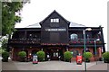
Great Bulls Head pub (site of) 228, Rotherhithe Street, London, SE16
Stood opposite the Bulls Head Dock Wharf from 1805'ish to 1888. Site now occupied by dwellings at the new junction with Katherine Close.
Image: © Chris Lordan
Taken: 24 Nov 2009
0.01 miles
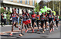
3
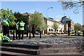
Salter Road
Seen from the steps beside Surrey Water, looking towards the YHA London Thameside Hostel. St.John Ambulance volunteers in the foreground are providing medical support for the London Marathon.
Image: © Martin Addison
Taken: 22 Apr 2012
0.03 miles
4
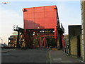
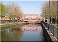
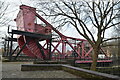
Iron Bridge, Surrey Water
A large single-span counterbalanced lifting bridge over the entrance to the dock known as Surrey Water.
Image: © Stephen Craven
Taken: 4 Jul 2006
0.03 miles
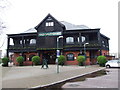
6
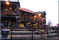
The Old Salt Quay in Rotherhithe
This pub used to be called the Spice Island.
Image: © Steve Daniels
Taken: 25 Jun 2012
0.03 miles
8
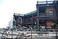
Rotherhithe: Former Surrey Basin Lock and bascule bridge
This lock used to provide the access to and from the River Thames for vessels wanting to dock in the Surrey Basin. The bascule bridge in the distance takes Rotherhithe Street over the waterway, and replaced a swing bridge, which was certainly still present when the Ordnance Survey mapped the locality in 1882.
Image: © Nigel Cox
Taken: 18 Apr 2010
0.03 miles
10
Elite Men in Rotherhithe
The Elite Men in the 2012 London Marathon are led along Salter Road by two pace makers past the YHA's London Thameside Hostel. The mens race was won in a time of 2:04.44 by Wilson Kipsang, who is visible in the centre of the group.
Image: © Martin Addison
Taken: 22 Apr 2012
0.03 miles