IMAGES TAKEN NEAR TO
Princes Riverside Road, LONDON, SE16 5RE
Introduction
This page details the photographs taken nearby to Princes Riverside Road, SE16 5RE by members of the Geograph project.
The Geograph project started in 2005 with the aim of publishing, organising and preserving representative images for every square kilometre of Great Britain, Ireland and the Isle of Man.

There are currently over 7.5m images from over14,400 individuals and you can help contribute to the project by visiting https://www.geograph.org.uk
Image Map
Images are licensed for reuse under creativecommons.org/licenses/by-sa/2.0
Notes
- Clicking on the map will re-center to the selected point.
- The higher the marker number, the further away the image location is from the centre of the postcode.
Image Listing (236 Images Found)
Images are licensed for reuse under creativecommons.org/licenses/by-sa/2.0
Image
Details
Distance
1
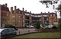
King & Queen pub (site of) 179, Rotherhithe Street, London SE16
This was a two-storeyed building first recorded in 1754 which disappeared about 1942. The side of the first floor, believed made of wooden slats, overhung the ground floor. Between 1754 and 1789 it was called the 'Ship Queensborough'. In 1792 the licensee was a Mr P Mestears and nearby was an alley named Mestears Rents. Today's 179 is some 50 yards to the east (right). Apologies for a boring picture but it gives an idea as to the vast loss of character to the area. That said, the area has improved by leaps and bounds re cleanliness.
Image: © Chris Lordan
Taken: 1 Dec 2009
0.01 miles
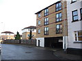
3
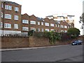
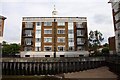
Amos Estate (part), Rotherhithe Street, London, SE16
There are another five buildings that complete the estate. The estate was named after the Rev. Andrew Amos (1863-1931) who in 1922 was the Rector of Clare College Mission in Abbeyfield Road, Rotherhithe. The estate was built upon Mestaers Buildings and an iron foundry.
Image: © Chris Lordan
Taken: 23 Sep 2009
0.02 miles
4
Rotherhithe Street, SE16
Bus stop on Rotherhithe Street.
Image: © Malc McDonald
Taken: 10 Oct 2010
0.03 miles
5
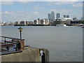
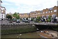
The view from New Crane Stairs
Looking across to Rotherhithe with Canary Wharf in the distance.
Image: © Alan Murray-Rust
Taken: 22 Jul 2008
0.04 miles
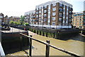
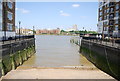
8
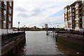
Former dock entrance by Woolcombes Court
Image: © Steve Daniels
Taken: 25 Jun 2012
0.05 miles
10
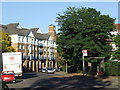
Boatswain and Call pub (site of) Rotherhithe Street, London, SE16
This stood from 1767 until 1810 at the junction with Charlotte Row, approximately where the right hand fir tree is shown. I'm not sure if this was once called the 'Charlotte Savage' as a pub with that name was in that immediate vicinity during the years shown. Just too difficult to even approximately isolate its location. Building on the far right is the ex Half Moon & Bulls Head pub.
Image: © Chris Lordan
Taken: 9 Dec 2009
0.05 miles