IMAGES TAKEN NEAR TO
Salter Road, LONDON, SE16 5LQ
Introduction
This page details the photographs taken nearby to Salter Road, SE16 5LQ by members of the Geograph project.
The Geograph project started in 2005 with the aim of publishing, organising and preserving representative images for every square kilometre of Great Britain, Ireland and the Isle of Man.

There are currently over 7.5m images from over14,400 individuals and you can help contribute to the project by visiting https://www.geograph.org.uk
Image Map (Loading...)


Getting Data...Please wait
Leaflet Map data © OpenStreetMap
Images are licensed for reuse under creativecommons.org/licenses/by-sa/2.0
Notes
- Clicking on the map will re-center to the selected point.
- The higher the marker number, the further away the image location is from the centre of the postcode.
Image Listing (281 Images Found)
Images are licensed for reuse under creativecommons.org/licenses/by-sa/2.0
Image
Details
Distance
1
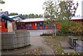
Redriff Primary School (part) Salter Road, Rotherhithe, London, SE16
On 25-04-1910 the first Redriff school opened as a three-storeyed building in Rotherhithe Street quite near Trinity Church. In 1939 most of the pupils were evacuated and on Saturday 07-09-1940 the school was totally destroyed, along with the Holy Trinity Church, by German bombs. Destroyed at the same time were buildings on a Roman Catholic area, bordering the south of the school, known as St Pelagius: chapel, convent [Sisters of Servants of the Sacred Heart], girls' home and a priest's house. The pupils returned in 1945 and were taught in houses etc. On 31-01-1949 a single-storey infant block was opened and the school progressed from there. The school was built upon Cow Lane and a large blacksmith's forge (Blacksmith Arms pub a little to the north). School closed 04-05-1990 and on 08-05-1990 they attended the school shown; that was about 200 yards away being built on what was once Lavender Dock. (In 2008 the school celebrated its centenary - after enquiries I establish this was based on the date the original foundations were laid).
Image: © Chris Lordan
Taken: 21 Oct 2009
0.03 miles
2
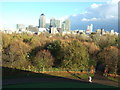
A view from Stave Hill, Rotherhithe, London
http://www.jbutler.org.uk/London/Southwark/Rotherhithe.shtml
Image: © Richard Humphrey
Taken: 11 Nov 2010
0.07 miles
3
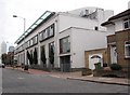
Noah's Ark pub (site of) 380 Rotherhithe Street, London SE16
It was about 150 yards east of Beatson Walk and at the junction of a narrow alley called "Screw Post Row". This would make it about where the nearest corner of the white building now stands. It was a three-storey pub, first recorded in 1805 and closed in 1933.
Image: © Chris Lordan
Taken: 19 Oct 2009
0.07 miles
5
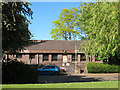
Surrey Docks Health Centre
From this angle, the building on Downtown Road, Rotherhithe appeared disused with the entrance door boarded up, but it still appears on an NHS website and others to be functioning, so presumably there is another entrance round the other side.
Image: © Stephen Craven
Taken: 22 May 2010
0.09 miles
6
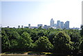
View E from Stave Hill
Docklands in the distance, Russia Dock Woods below.
Image: © N Chadwick
Taken: 7 Jul 2013
0.11 miles
7
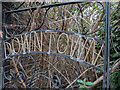
Overgrown Gate, Downton Road, Rotherhithe, SE1
Image: © Christine Matthews
Taken: 10 Mar 2016
0.11 miles
8
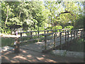
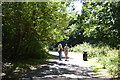
Wooden footbridge in Russia Dock Woodland
One of several such bridges in this urban park.
Image: © Stephen Craven
Taken: 22 May 2010
0.11 miles
9

Housing Estate, Rotherhithe, SE1
Image: © Christine Matthews
Taken: 10 Mar 2016
0.11 miles
10
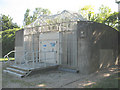
Electrical installation on Downtown Road
A very heavily guarded substation: OpenStreetMap shows a shaft to the Jubilee Line here, so perhaps this is the electrical supply to the trains, or powering ventilation fans?
Image: © Stephen Craven
Taken: 22 May 2010
0.11 miles