IMAGES TAKEN NEAR TO
Rotherhithe Street, LONDON, SE16 5HB
Introduction
This page details the photographs taken nearby to Rotherhithe Street, SE16 5HB by members of the Geograph project.
The Geograph project started in 2005 with the aim of publishing, organising and preserving representative images for every square kilometre of Great Britain, Ireland and the Isle of Man.

There are currently over 7.5m images from over14,400 individuals and you can help contribute to the project by visiting https://www.geograph.org.uk
Image Map
Images are licensed for reuse under creativecommons.org/licenses/by-sa/2.0
Notes
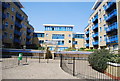
- Clicking on the map will re-center to the selected point.
- The higher the marker number, the further away the image location is from the centre of the postcode.
Image Listing (252 Images Found)
Images are licensed for reuse under creativecommons.org/licenses/by-sa/2.0
Image
Details
Distance
1
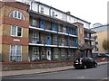
Watermans Arms pub (site of) 656, Rotherhithe Street, London, SE16
First recorded in 1860 and lasted until 1933 opposite the entrance to Trinity Wharf. The site is now occupied by Bryan House. Somewhere to its right, at number 642, stood the 'India Arms' pub (1813 to 1929) but I could not even guess as to where its location was.
Image: © Chris Lordan
Taken: 24 Nov 2009
0.01 miles
2
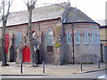
Ebenezer Norwegian Church
The Norwegian seaman's mission church in Rotherhithe Street opposite the Redriff Estate. Opened 26-07-1871 to 1929 and later became a Dockland Settlement.
Image: © Chris Lordan
Taken: 21 Jun 2007
0.03 miles
5
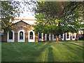
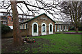
Holy Trinity church hall, Rotherhithe
The building is a former infant school. For a detailed history, see Image
Image: © Stephen Craven
Taken: 2 May 2013
0.04 miles
6
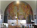
Holy Trinity, Rotherhithe: mural
The mural is one of several in postwar London churches by Hans Feibusch and shows the dying Christ attended by angels.
Image: © Stephen Craven
Taken: 2 May 2013
0.04 miles
7
![India Arms pub [1 of 2] (site of) Rotherhithe Street, London, SE16](https://s0.geograph.org.uk/geophotos/01/60/40/1604056_49953cec_120x120.jpg)
India Arms pub [1 of 2] (site of) Rotherhithe Street, London, SE16
Believed this was first recorded in 1743 and demolished 1806/8. A timber building on the riverside of the street and at the south end of Durands Wharf, site of which is depicted. It was rebuilt practically opposite its original location. See India Arms [2 of 2]. When built it was believed to have been the 'Golden Anchor'. It would have stood about 170 yards from today's 'Clipper' pub.http://www.geograph.org.uk/photo/1604060
Image: © Chris Lordan
Taken: 1 Dec 2009
0.04 miles
8
![India Arms pub [2 of 2] (site of) Rotherhithe Street, London, SE16](https://s0.geograph.org.uk/geophotos/01/60/40/1604060_b9f145db_120x120.jpg)
India Arms pub [2 of 2] (site of) Rotherhithe Street, London, SE16
Built about 1808 on the landside of the street and ceased trading in 1929. It replaced the original that was on the opposite side of the road from 1743 to 1806/8. The approximate site is now occupied by numbers 612/4 Rotherhithe Street. http://www.geograph.org.uk/photo/1604056
Image: © Chris Lordan
Taken: 1 Dec 2009
0.04 miles
9
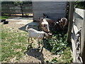
Goats at Surrey Docks Farm
Surrey Docks Farm was first established in 1975 on a site near Greenland Dock to the south of its present site. In June 1986 the farm was relocated to its present site alongside the River Thames at South Wharf. This was a very hot day so shade was sought after by the animals.
See the farm's website for full information - www.surreydocksfarm.org.uk
Image: © Marathon
Taken: 25 Jun 2024
0.04 miles
10
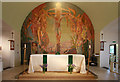
Holy Trinity, Rotherhithe Street, Rotherhithe - Sanctuary
Image: © John Salmon
Taken: 17 Feb 2011
0.05 miles