IMAGES TAKEN NEAR TO
Rotherhithe Street, LONDON, SE16 5EH
Introduction
This page details the photographs taken nearby to Rotherhithe Street, SE16 5EH by members of the Geograph project.
The Geograph project started in 2005 with the aim of publishing, organising and preserving representative images for every square kilometre of Great Britain, Ireland and the Isle of Man.

There are currently over 7.5m images from over14,400 individuals and you can help contribute to the project by visiting https://www.geograph.org.uk
Image Map
Images are licensed for reuse under creativecommons.org/licenses/by-sa/2.0
Notes
- Clicking on the map will re-center to the selected point.
- The higher the marker number, the further away the image location is from the centre of the postcode.
Image Listing (267 Images Found)
Images are licensed for reuse under creativecommons.org/licenses/by-sa/2.0
Image
Details
Distance
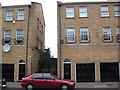
1
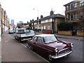
Ford Consul parked on Rotherhithe Street
Image: © Chris Whippet
Taken: 9 Feb 2014
0.02 miles
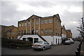
2
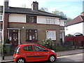
Dolphin public house - site of
This was at 368 Rotherhithe Street, London SE16 from 1859 to 1870. A few yards to its right was the "Three Compasses" and a few yards to its left the "Noah's Ark" pub. The two dwellings shown fit the criteria for the location and are numbers 366 and 368.
Image: © Chris Lordan
Taken: 10 Apr 2011
0.02 miles
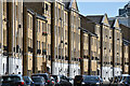
3
Swallows Galley pub (site of) 446, Rotherhithe Street, London, SE16
This stood practically opposite the old Horseferry Wharf from 1767 to 1933. I found it difficult to get an exact location but it must have been within yards of today's number 446 that is to the right of the palm trees.
Image: © Chris Lordan
Taken: 24 Nov 2009
0.02 miles
4
Black Bull pub (site of) 396, Rotherhithe Street, London, SE16
I do not know anything about this pub other than it was listed in the 1856 GPO records. Today's '396' would be where the corner of the white building stands - this would be correct in relation to 'Noahs Ark' which was at number 380. It is possible that this site was, between 1767 and 1796, called the 'Golden Sun and Sugar Loaf' pub. If not that pub was very close by.
Image: © Chris Lordan
Taken: 24 Nov 2009
0.02 miles
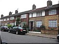
5
King & Queen Dock pub (site of) 227, Rotherhithe Street, London, SE16
First recorded about 1805 and last noted in 1887. Image shows its approximate position as it was near some river steps. Today's 227 is the building on the right.
Image: © Chris Lordan
Taken: 24 Nov 2009
0.03 miles
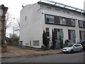
7
Houses along the curve of Rotherhithe Street
Image: © David Martin
Taken: 10 Apr 2022
0.03 miles
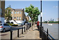
8
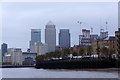
Lavender Wharf, Rotherhithe
With Canary Wharf in the background.
Image: © Mike Pennington
Taken: 14 Nov 2017
0.04 miles
10
The Thames Path on Sovereign Crescent
Image: © Steve Daniels
Taken: 25 Jun 2012
0.05 miles