IMAGES TAKEN NEAR TO
Edward Square, LONDON, SE16 5EE
Introduction
This page details the photographs taken nearby to Edward Square, SE16 5EE by members of the Geograph project.
The Geograph project started in 2005 with the aim of publishing, organising and preserving representative images for every square kilometre of Great Britain, Ireland and the Isle of Man.

There are currently over 7.5m images from over14,400 individuals and you can help contribute to the project by visiting https://www.geograph.org.uk
Image Map
Images are licensed for reuse under creativecommons.org/licenses/by-sa/2.0
Notes
- Clicking on the map will re-center to the selected point.
- The higher the marker number, the further away the image location is from the centre of the postcode.
Image Listing (350 Images Found)
Images are licensed for reuse under creativecommons.org/licenses/by-sa/2.0
Image
Details
Distance
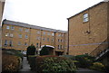
1
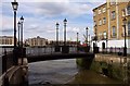
Footbridge over Lavender Wharf
The Thames Path crosses the footbridge.
Image: © Steve Daniels
Taken: 25 Jun 2012
0.01 miles
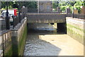
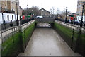
3
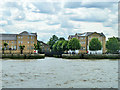
Former entrance to Surrey Docks via Lavender Lock
This was a way into the docks via Lavender Lock and (timber) Pond, later Dock. It was eliminated as a navigable link and a pumping station inserted in the 1920s. This was to maintain the water level in the docks. The pumphouse is glimpsed beyond the more recent buildings. It is no longer functional, the docks have gone, but a tiny fragment remains beyond the pumphouse called Lavender Pond, a local nature reserve and amenity.
Image: © Robin Webster
Taken: 30 Jun 2011
0.01 miles
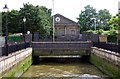
7
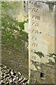
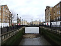
Depth gauge on former lockside
Historic Ordnance Survey mapping shows this as a former entrance to Lavender Dock, although it was disused long before the docks were closed, serving as a water channel to a pumping station.
Image: © David Martin
Taken: 10 Apr 2022
0.02 miles
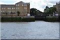
9
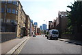
Rotherhithe Street crosses Lavender Wharf
The Pumphouse Educational Museum is on the far side of the bridge.
Image: © Steve Daniels
Taken: 25 Jun 2012
0.02 miles