IMAGES TAKEN NEAR TO
Bermondsey Wall West, LONDON, SE16 4TH
Introduction
This page details the photographs taken nearby to Bermondsey Wall West, SE16 4TH by members of the Geograph project.
The Geograph project started in 2005 with the aim of publishing, organising and preserving representative images for every square kilometre of Great Britain, Ireland and the Isle of Man.

There are currently over 7.5m images from over14,400 individuals and you can help contribute to the project by visiting https://www.geograph.org.uk
Image Map
Images are licensed for reuse under creativecommons.org/licenses/by-sa/2.0
Notes
- Clicking on the map will re-center to the selected point.
- The higher the marker number, the further away the image location is from the centre of the postcode.
Image Listing (679 Images Found)
Images are licensed for reuse under creativecommons.org/licenses/by-sa/2.0
Image
Details
Distance
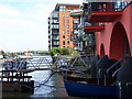
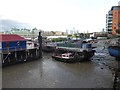
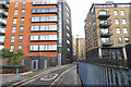
2
Waterfront buildings in Bermondsey
On the Upper Pool of the Port of London. Although little port trade is carried out now, the piers in the picture are mostly occupied by barges and other commercial rivercraft. On the right, under construction, is 'The Shard', designed by Renzo Piano and due, when completed in 2012, to be the tallest building in the European Union at 1017 feet (310m).
Image: © Rod Allday
Taken: 19 Mar 2011
0.01 miles
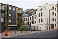
3
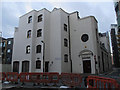
St Saviour's House, Bermondsey Wall West
The only online reference I could find to this building, other than property agents' websites, was the deposit of document with the Museum of London in 2010 by Pre Construct Archaeology Ltd, reference BYA00.
Image: © Stephen Craven
Taken: 8 Mar 2015
0.02 miles
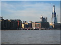
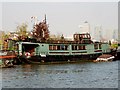
5
Houseboat village on the Thames at low tide
This view is from Jacobs Island Pier. The nearby Jacob's Island was an area of notorious poverty where Charles Dickens set portions of his novel Oliver Twist - see https://www.geograph.org.uk/photo/6294916
Efforts have been made in the past to move these houseboats but they are still here. What is particularly remarkable is the size of some of the trees growing on the boats.
Image: © Marathon
Taken: 9 Oct 2019
0.03 miles
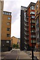
6
Providence Square
Ironically, a square apartment block on George Row. The adjacent cream building appears to be an original industrial building converted to housing.
Image: © Martin Addison
Taken: 22 Oct 2010
0.03 miles
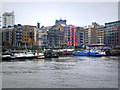
8
Barges Moored Near St.Saviour's Dock, London
Barges moored at the pier, on the River Thames, just down river of St.Saviour's Dock. Offices, at Canary Wharf, can be seen on the horizon.
Image: © Peter Trimming
Taken: 21 Mar 2010
0.03 miles
9
Turf Zone "BermondWall"
Bermondsey Wall West, London.
Image: © Ian S
Taken: 24 Dec 2022
0.03 miles
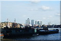
10
Thames houseboat
A placid river scene, with the towers of commerce visible on the distant Isle of Dogs.
Image: © Patrick Mackie
Taken: 18 Apr 2010
0.03 miles