IMAGES TAKEN NEAR TO
St. James's Road, LONDON, SE16 4QZ
Introduction
This page details the photographs taken nearby to St. James's Road, SE16 4QZ by members of the Geograph project.
The Geograph project started in 2005 with the aim of publishing, organising and preserving representative images for every square kilometre of Great Britain, Ireland and the Isle of Man.

There are currently over 7.5m images from over14,400 individuals and you can help contribute to the project by visiting https://www.geograph.org.uk
Image Map
Images are licensed for reuse under creativecommons.org/licenses/by-sa/2.0
Notes
- Clicking on the map will re-center to the selected point.
- The higher the marker number, the further away the image location is from the centre of the postcode.
Image Listing (267 Images Found)
Images are licensed for reuse under creativecommons.org/licenses/by-sa/2.0
Image
Details
Distance
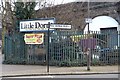
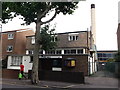
1
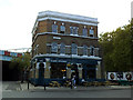
St James Tavern, reopened
Since my earlier photo three years ago Image, the pub was closed and under threat of being demolished or converted to housing, but has recently reopened under new management.
Image: © Stephen Craven
Taken: 15 May 2014
0.00 miles
2
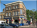
St James Tavern
A pub on the corner of St James Road (right) and Linsey Street (foreground).
Image: © Stephen Craven
Taken: 2 Jun 2011
0.01 miles
3
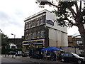
The St. James Tavern, Bermondsey
Public house on Southwark Park Road (in front) and Linsey Street (behind the pub).
In the background are railway arches of the railway lines to London Bridge.
Image: © David Anstiss
Taken: 25 Sep 2011
0.01 miles
5
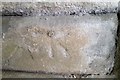
Ordnance Survey 1GL Bolt
This OS Bolt can be found on the SW buttress of the railway viaduct. It marks a point 2.699m above mean sea level.
Image: © Adrian Dust
Taken: 15 Aug 2016
0.01 miles
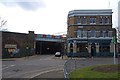
6
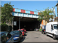
Linsey Street railway bridge
The London-Greenwich railway was generally built of arches all the way along, even when crossing roads. But here where it crosses Linsey Street (which is now a stub of a road at this end) there is a girder bridge. This is probably because Spa Road station was sited just to the right of the bridge. it closed in 1915.
Image: © Stephen Craven
Taken: 2 Jun 2011
0.02 miles
8
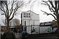
View of "Beer Here" on the side of the St. James of Bermondsey pub from St. James's Road
Looking south-southeast.
Image: © Robert Lamb
Taken: 27 Jan 2019
0.02 miles
9
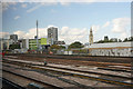
Railway line through Bermondsey
The line terminates at London Bridge Station. A distinctive landmark is the spire of St James' Church, Bermondsey which was one of the Waterloo Churches.
Image: © Bill Boaden
Taken: 9 Oct 2015
0.03 miles
10
Gospel Hall, Bermondsey
On Webster Road.
In the background is Image
Image: © David Anstiss
Taken: 25 Sep 2011
0.03 miles