IMAGES TAKEN NEAR TO
Janeway Street, LONDON, SE16 4PS
Introduction
This page details the photographs taken nearby to Janeway Street, SE16 4PS by members of the Geograph project.
The Geograph project started in 2005 with the aim of publishing, organising and preserving representative images for every square kilometre of Great Britain, Ireland and the Isle of Man.

There are currently over 7.5m images from over14,400 individuals and you can help contribute to the project by visiting https://www.geograph.org.uk
Image Map (Loading...)


Getting Data...Please wait
Leaflet Map data © OpenStreetMap
Images are licensed for reuse under creativecommons.org/licenses/by-sa/2.0
Notes
- Clicking on the map will re-center to the selected point.
- The higher the marker number, the further away the image location is from the centre of the postcode.
Image Listing (435 Images Found)
Images are licensed for reuse under creativecommons.org/licenses/by-sa/2.0
Image
Details
Distance
1
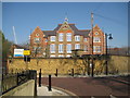
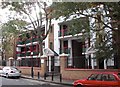
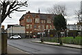
Bermondsey: Riverside Primary School
This school was originally the Farncombe Street Board School completed in 1874 by the London School Board in the ecclesiastical Gothic Revival style popular in Victorian times. It is a Grade II Listed Building by virtue of this. The steeply pitched outer gable ends have stone quatrefoils with three light slits above, while the whole building is capped with a cupola containing the school bell, itself capped with a weather vane.
Farncombe Street has disappeared off the map entirely but maybe one of the surrounding streets was renamed.
Just how well a building like this serves today's school population is a matter of debate.
This view was taken from Janeway Street.
Image: © Nigel Cox
Taken: 18 Apr 2010
0.04 miles
2

Wilson Grove, Bermondsey
Inter-war 'garden city' housing is, perhaps, an unexpected find in this inner-city district. These are some of the 'Salter Cottages', named after Ada Salter who was the first ever woman councillor in Britain in 1910, and was the inspiration behind this development as a replacement for the appalling slums that had previously occupied the area. They were built in 1928.
Image: © Stephen McKay
Taken: 27 Jul 2007
0.05 miles
3
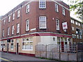
Crown pub
At 440 Southwark Park Road. Original was built in 1858 and this one about 1959 with the building of the Slippers Place Estate
Image: © Chris Lordan
Taken: 29 Aug 2007
0.05 miles
4
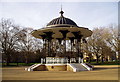
Bandstand - Southwark Park, Rotherhithe, SE16
Erected in 1998 as an exact replica of the original (melted down for scrap during the Second World War), which was one of a pair designed in 1861 by Captain Francis Fowke for the Royal Horticultural Society in South Kensington. That site is now occupied by the Royal Albert Hall, also designed by Capt Fowke. The pair were bought by the then London County Council, the other being erected in Peckham Rye Park. https://www.dorothearestorations.com/case-studies/congleton-bandstand
Image: © Chris Lordan
Taken: 20 Jan 2008
0.05 miles
5
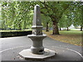
Drinking Fountain - Southwark Park, Rotherhithe, SE16
Erected in the north section of the park in 1884 being paid for by public subscriptions. Believed the first public memorial to a working man, Jabez West, who from 1875 was a leading member of the Bermondsey Temperance Movement.
Image: © Chris Lordan
Taken: 9 Sep 2009
0.05 miles
6
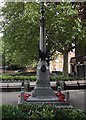
War Memorial - West Lane, Rotherhithe, SE16
Dedicated to the men of Bermondsey and Rotherhithe who died in WWI and later to those who died in WWII and subsequent conflicts. Unveiled 3-00pm Saturday 8th October 1921 with a great deal of the finances supplied by Peak Freans Ltd - biscuit manufacturers of Bermondsey. West Lane is / was the boundary between Bermondsey and Rotherhithe.
Image: © Chris Lordan
Taken: 9 Sep 2009
0.05 miles
7
Millpond Estate (part) Rotherhithe, London, SE16
The estate is bounded by Bermondsey Wall East (previously Rotherhithe Street), West Lane and Paradise Street. Named after the Mill Pond that was once about 500 yards south of the estate off Southwark Park Road. In 1588 gravel was required for ballast in ships for the defence of the Thames against a possible Spanish invasion. A hole was dug, gravel excavated, hole filled with water = the pond. Over many years various buildings sprung up nearby but in 1902 the pond was filled in after being described as "that receptacle of abominations". The estate was built over Gillam Court, Donne Place and Wormald Place.
Image: © Chris Lordan
Taken: 23 Sep 2009
0.05 miles
8
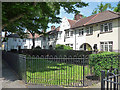
Wilson Grove
A mini-garden city, the houses built in 1928 by Culpin & Bowers.
See also Image
Image: © Stephen Richards
Taken: 26 May 2013
0.06 miles
9
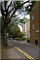
Marigold Street
One of several narrow sidestreets running through the estate beside Cherry Garden Pier.
Image: © Martin Addison
Taken: 22 Oct 2010
0.06 miles
10
Riverside Primary School
Grade II listed.
Image: © N Chadwick
Taken: 2 Feb 2023
0.06 miles