IMAGES TAKEN NEAR TO
Emba Street, LONDON, SE16 4PL
Introduction
This page details the photographs taken nearby to Emba Street, SE16 4PL by members of the Geograph project.
The Geograph project started in 2005 with the aim of publishing, organising and preserving representative images for every square kilometre of Great Britain, Ireland and the Isle of Man.

There are currently over 7.5m images from over14,400 individuals and you can help contribute to the project by visiting https://www.geograph.org.uk
Image Map
Images are licensed for reuse under creativecommons.org/licenses/by-sa/2.0
Notes
- Clicking on the map will re-center to the selected point.
- The higher the marker number, the further away the image location is from the centre of the postcode.
Image Listing (480 Images Found)
Images are licensed for reuse under creativecommons.org/licenses/by-sa/2.0
Image
Details
Distance
1
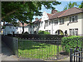
Wilson Grove
A mini-garden city, the houses built in 1928 by Culpin & Bowers.
See also Image
Image: © Stephen Richards
Taken: 26 May 2013
0.01 miles
2
Marigold Street, Bermondsey
The name is an ancient one: genealogy sites record people living here in 1825. The present buildings are much more recent.
Image: © Stephen Craven
Taken: 8 Mar 2015
0.03 miles
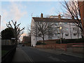
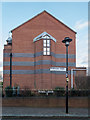
4
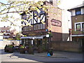
Old Justice Public House, Bermondsey Wall East, London SE16
Image: © Christine Matthews
Taken: 8 Mar 2015
0.04 miles
5
Marigold Street
One of several narrow sidestreets running through the estate beside Cherry Garden Pier.
Image: © Martin Addison
Taken: 22 Oct 2010
0.04 miles
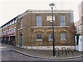
6
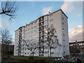
Morriss House, Marigold Street, London SE16
It is spelt that way Image]
Image: © Christine Matthews
Taken: 8 Mar 2015
0.04 miles
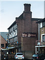
7
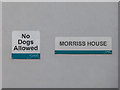
Name Plaque on Morriss House, Marigold Street, London SE16
Here is a view of the whole apartment block Image]
Image: © Christine Matthews
Taken: 8 Mar 2015
0.04 miles
9
The Old Justice Pub, Bermondsey
Bermondsey Wall East, Bermondsey LONDON SE16 4LY near to The River Thames Tideway
Image: © canalandriversidepubs co uk
Taken: 23 Apr 2010
0.04 miles
10
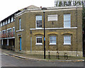
Bermondsey: Duffield Sluice offices
The date stone between the first-floor windows reads
Sewers Surrey & Kent
Duffield Sluice
1822.
Built by the Surrey and Kent Commission of Sewers, according to some sources this was an office block for a pumping station since demolished. Apparently most of the sewers in the area were below the level of the Thames at high tide, so sluice gates managed the flow into the river.
Image: © John Sutton
Taken: 2 Nov 2019
0.04 miles