IMAGES TAKEN NEAR TO
St. Marychurch Street, LONDON, SE16 4JE
Introduction
This page details the photographs taken nearby to St. Marychurch Street, SE16 4JE by members of the Geograph project.
The Geograph project started in 2005 with the aim of publishing, organising and preserving representative images for every square kilometre of Great Britain, Ireland and the Isle of Man.

There are currently over 7.5m images from over14,400 individuals and you can help contribute to the project by visiting https://www.geograph.org.uk
Image Map (Loading...)


Getting Data...Please wait
Leaflet Map data © OpenStreetMap
Images are licensed for reuse under creativecommons.org/licenses/by-sa/2.0
Notes
- Clicking on the map will re-center to the selected point.
- The higher the marker number, the further away the image location is from the centre of the postcode.
Image Listing (676 Images Found)
Images are licensed for reuse under creativecommons.org/licenses/by-sa/2.0
Image
Details
Distance
1
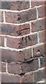
Ordnance Survey Cut Mark
This OS cut mark can be found on the SE face of No1 Henley Close. It marks a point 3.713m above mean sea level.
Image: © Adrian Dust
Taken: 15 Aug 2016
0.03 miles
2
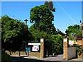
Time and Talents, Rotherhithe
This site on Rupack Street, of which the gateway is seen here, is one of several venues of a charity that traces its roots back to the Settlement movement in 1889 - see http://www.timeandtalents.org.uk/
Image: © Stephen Craven
Taken: 22 May 2010
0.03 miles
3
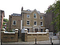
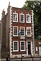
The old rectory, Rotherhithe
St Mary's Rectory Image was being converted to private sector housing. There is now a plaque Image to its last clergy occupant.
Image: © Stephen Craven
Taken: 20 Sep 2014
0.03 miles
4
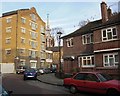
Ship pub (site of) 58, St Marychurch Street, Rotherhithe, London, SE16
I do not know the dates regarding its opening / closing but at a guess I believe it was demolished in the early 1930's. Reason - photographer standing on the forecourt of the existing 'Ship' that was built as a replacement in 1939. Site now occupied by Henley Close and in the background can be seen the tower / spire of St Mary's Church.
Image: © Chris Lordan
Taken: 1 Dec 2009
0.03 miles
5
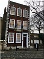
St Mary School in Rotherhithe
Founded by Peter Hill and Robert Bell in 1613. Removed here 1797. Peter Hill gave £3 a year to the master to teach eight children, ‘sons of seafaring men'.
Image: © Steve Daniels
Taken: 25 Jun 2012
0.03 miles
6
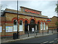
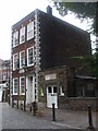
St Mary's Free School, Rotherhithe
Not to be confused with the modern version. The old watch house is to the right and now acts as a cafe.
Image: © Brian Whittle
Taken: 6 Jan 2018
0.03 miles
8
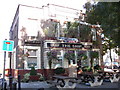
The Ship pub. 39, St Marychurch Street, Rotherhithe, London, SE16
At the junction with Elephant Lane (left) and built in 1939. Prior to this on half of the site was a newsagents 'E M Murphy'. The original pub, built about 1757, was on the opposite side of the road at number 58.
Image: © Chris Lordan
Taken: 12 Oct 2009
0.03 miles
9
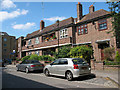
Rupack Street
One of several low-rise residential blocks comprising the Adams Gardens Estate.
Image: © Stephen Craven
Taken: 21 May 2011
0.03 miles