IMAGES TAKEN NEAR TO
Old Jamaica Road, LONDON, SE16 4ER
Introduction
This page details the photographs taken nearby to Old Jamaica Road, SE16 4ER by members of the Geograph project.
The Geograph project started in 2005 with the aim of publishing, organising and preserving representative images for every square kilometre of Great Britain, Ireland and the Isle of Man.

There are currently over 7.5m images from over14,400 individuals and you can help contribute to the project by visiting https://www.geograph.org.uk
Image Map
Images are licensed for reuse under creativecommons.org/licenses/by-sa/2.0
Notes
- Clicking on the map will re-center to the selected point.
- The higher the marker number, the further away the image location is from the centre of the postcode.
Image Listing (332 Images Found)
Images are licensed for reuse under creativecommons.org/licenses/by-sa/2.0
Image
Details
Distance
1
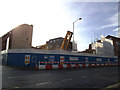
Demolition site, Abbey Street, Bermondsey
I am unsure what was here before, on the corner of Old Jamaica Road.
Image: © Stephen Craven
Taken: 25 Jan 2014
0.01 miles
2
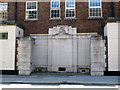
London Regiment War Memorial, Bermondsey
The memorial is on the wall of a building on Old Jamaica Road, and commemorates the casualties of the 22nd Battalion London Regiment in the First World War. The inscription on the two end pillars is in Latin with an English translation: "be thou mindful of the courage of him that is fallen: for his very ashes do cry out in triumph". It is listed grade 2 (List Entry Number 1393871).
Image: © Stephen Craven
Taken: 25 May 2012
0.01 miles
3
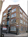
East end of Neckinger Mill
The other end of this grade 2 listed former warehouse from 1864 http://list.english-heritage.org.uk/resultsingle.aspx?uid=1393907 is best seen from the railway Image
Image: © Stephen Craven
Taken: 8 Mar 2015
0.02 miles
4
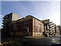
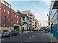
New and old buildings, Old Jamaica Road, Bermondsey
A new building on the corner of Old Jamaica Road and Abbey Street, part of the Bermondsey Spa development; beyond it a much older one, Lilliput Hall Image, and beyond that new build again - the Parker Building.
Image: © Stephen Craven
Taken: 25 Jan 2014
0.02 miles

6
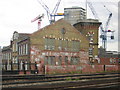
Bermondsey: former factory, from the train
On the gable end, the inscription reads "Neckinger Mill / Bevingtons and Sons". The Neckinger is one of London's lost rivers, visible above ground now only as St Saviour's Dock (the creek by which it enters the Thames).
Image: © Christopher Hilton
Taken: 7 Jun 2011
0.02 miles
8
Lilliput Hall, Old Jamaica Road
A former pub, now converted to residential use. A photo on another site http://deadpubs.co.uk/LondonPubs/Bermondsey/LilliputHall.shtml shows that its timber beams have been repainted black since 2009.
Image: © Stephen Craven
Taken: 25 May 2012
0.03 miles
9
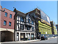
Old Jamaica Road, London SE1
The Tudor style building on the left is not as old as it looks.
Image: © Christine Matthews
Taken: 8 Mar 2015
0.03 miles
10

Old Jamaica Road, London SE1
The Tudor style building on the left is not as old as it looks.
Image: © Christine Matthews
Taken: 8 Mar 2015
0.03 miles