IMAGES TAKEN NEAR TO
Ness Street, LONDON, SE16 4AR
Introduction
This page details the photographs taken nearby to Ness Street, SE16 4AR by members of the Geograph project.
The Geograph project started in 2005 with the aim of publishing, organising and preserving representative images for every square kilometre of Great Britain, Ireland and the Isle of Man.

There are currently over 7.5m images from over14,400 individuals and you can help contribute to the project by visiting https://www.geograph.org.uk
Image Map
Images are licensed for reuse under creativecommons.org/licenses/by-sa/2.0
Notes
- Clicking on the map will re-center to the selected point.
- The higher the marker number, the further away the image location is from the centre of the postcode.
Image Listing (310 Images Found)
Images are licensed for reuse under creativecommons.org/licenses/by-sa/2.0
Image
Details
Distance
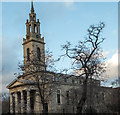
1
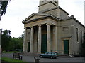
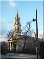
St James Church, Thurland Road, SE16 (1)
Showing the lower half of the building. For a picture of the spire, click here Image
Image: © Danny P Robinson
Taken: 15 Jun 2007
0.01 miles
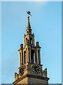
2
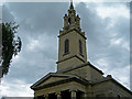
St James Church, Thurland Road, SE16 (2)
Showing the spire -- for a picture at ground level click here Image
Image: © Danny P Robinson
Taken: 15 Jun 2007
0.01 miles
3
Frean Street, Bermondsey
A largely pedestrianised street, part of the Bermondsey Spa estate.
Image: © Stephen Craven
Taken: 25 May 2012
0.01 miles
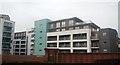
5
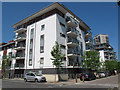
Spa Road, Bermondsey
Recently-built apartment blocks on Spa Road, part of the Bermondsey Spa development. The bridge in the background is listed grade II (List entry Number 1385932) as the oldest surviving railway bridge in London.
Image: © Stephen Craven
Taken: 25 May 2012
0.02 miles
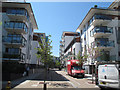
6
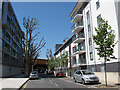
Thurland Road, Bermondsey
Recently-built apartment blocks on Thurland Road, part of the Bermondsey Spa development.
Image: © Stephen Craven
Taken: 25 May 2012
0.02 miles
7
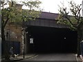
Spa Road Railway Bridge (2)
Spa Road leads from Thurland Road towards Grange Road.
It passes under a Grade II listed railway bridge, carrying many railway lines from South Bermondsey, New Cross, New Cross Gate and Deptford towards London Bridge (and Cannon Street).
See http://www.britishlistedbuildings.co.uk/en-471352-railway-bridge-bermondsey for more details about the bridge.
Image: © David Anstiss
Taken: 25 Sep 2011
0.03 miles
8
St James Church, Bermondsey, London SE1
Image: © Christine Matthews
Taken: 8 Mar 2015
0.04 miles
9
Clock, St James Church, Bermondsey, London SE1
Image: © Christine Matthews
Taken: 8 Mar 2015
0.04 miles
10
St James Church, Bermondsey, London SE1
Image: © Christine Matthews
Taken: 8 Mar 2015
0.04 miles