IMAGES TAKEN NEAR TO
Cadbury Way, LONDON, SE16 3XA
Introduction
This page details the photographs taken nearby to Cadbury Way, SE16 3XA by members of the Geograph project.
The Geograph project started in 2005 with the aim of publishing, organising and preserving representative images for every square kilometre of Great Britain, Ireland and the Isle of Man.

There are currently over 7.5m images from over14,400 individuals and you can help contribute to the project by visiting https://www.geograph.org.uk
Image Map
Images are licensed for reuse under creativecommons.org/licenses/by-sa/2.0
Notes
- Clicking on the map will re-center to the selected point.
- The higher the marker number, the further away the image location is from the centre of the postcode.
Image Listing (157 Images Found)
Images are licensed for reuse under creativecommons.org/licenses/by-sa/2.0
Image
Details
Distance
1
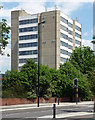
Former Aylwin School, Southwark Park Road
By Mayorcas & Guest, 1965. The concrete looks in good nick.
Now a Harris academy.
Image: © Stephen Richards
Taken: 27 May 2013
0.05 miles
2
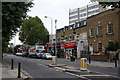
Southwark Park Road
A small parade of shops with flats above located between and opposite Reverdy Road and Alma Grove. A street cleaner can be seen going about his lonely business.
Image: © Martin Addison
Taken: 22 Oct 2010
0.08 miles
3
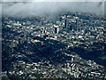
The City of London from the air
Looking over Bermondsey, Tower Bridge, St Paul's Cathedral, The Shard, The Walkie Talkie building (20 Fenchurch Street) and The Gherkin (30 St Mary Axe) are all visible. Taken from a Heathrow bound flight from Glasgow.
Image: © Thomas Nugent
Taken: 18 Mar 2014
0.08 miles
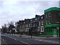
5

Southwark Park Road
A sweeping curve on the road as it passes the Longfield Estate - the low-rise blocks of which are on the left of the photo.
Image: © Martin Addison
Taken: 22 Oct 2010
0.10 miles
7
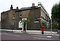
Church Cottage
Located on the corner of Reverdy Road, at the junction with Southwark Park Road, this house seems to have had some repairs to its walls in the past. The name 'Church Cottage' on the lintel above the door is just visible through a layer of cream paint. I have been unable to ascertain whether there was a link with the nearby St. Annes church, the current vicarage of which is located on Thorburn Square.
Image: © Martin Addison
Taken: 22 Oct 2010
0.11 miles
8

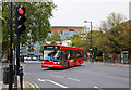
Grange Road
Seen from close to the junction with Dunton Road, a number 1 bus stops to collect passengers on route to Canada Water from Tottenham Court Road. Behind the bus is Artesian House, a modern apartment block. It was designed by Pollard Thomas Edwards architects and contains a mix of living accommodation and neighbourhood resources (including a health spa). It was part of the Bermondsey Spa Regeneration initiative and was completed in 2007.
Image: © Martin Addison
Taken: 22 Oct 2010
0.12 miles
9
Turning Onto Dunton Road
A 78 bus sneaks through as the lights change on route to Nunhead from Shoreditch. The vehicle is a Dennis Dart with Alexander ALX200 bodywork. This combination is relatively rare in London with the equivalent Plaxton Pointer being a much more common choice.
Image: © Martin Addison
Taken: 22 Oct 2010
0.12 miles
10
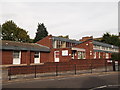
Southwark Age Concern
On Southwark Park Road.
Image: © David Anstiss
Taken: 25 Sep 2011
0.12 miles