IMAGES TAKEN NEAR TO
Woolstaplers Way, LONDON, SE16 3UU
Introduction
This page details the photographs taken nearby to Woolstaplers Way, SE16 3UU by members of the Geograph project.
The Geograph project started in 2005 with the aim of publishing, organising and preserving representative images for every square kilometre of Great Britain, Ireland and the Isle of Man.

There are currently over 7.5m images from over14,400 individuals and you can help contribute to the project by visiting https://www.geograph.org.uk
Image Map
Images are licensed for reuse under creativecommons.org/licenses/by-sa/2.0
Notes
- Clicking on the map will re-center to the selected point.
- The higher the marker number, the further away the image location is from the centre of the postcode.
Image Listing (248 Images Found)
Images are licensed for reuse under creativecommons.org/licenses/by-sa/2.0
Image
Details
Distance
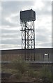
1
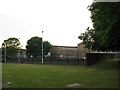
Play area near Linsey Street
The play area consists of some open grass, and an enclosed clay-surfaced area currently used as a basketball court.
Image: © Stephen Craven
Taken: 1 Jun 2011
0.04 miles
2
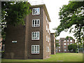
Helen Taylor House
One of the blocks of housing making up the Eveline Lowe Estate in Bermondsey. This one has four storeys and faces Linsey Street.
Image: © Stephen Craven
Taken: 1 Jun 2011
0.06 miles
3
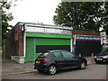
Alma Cars, Linsey Street
A taxi firm that presumably takes its name from the nearby school. The adjacent shop unit was vacant at the time of this photo.
Image: © Stephen Craven
Taken: 1 Jun 2011
0.07 miles
4
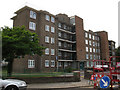
William Rushbrooke House
One of the five-storey blocks of housing making up the Eveline Lowe Estate in Bermondsey. This one faces Linsey Street.
Image: © Stephen Craven
Taken: 1 Jun 2011
0.07 miles
7
Linsey Street, 48 years on
This is a recreation of the view in the 1963 photo at http://www.geograph.org.uk/photo/2026569 Image
Only the low wall and metal fence around the grassed area in the foreground gives a fix: everything else has changed. The railway arches in the distance in the earlier photo are now hidden behind later buildings, and the terraced housing on Linsey Street itself has been demolished. Linsey Street is now a dead-end although a stub of it remains beyond the railway viaduct.
Image: © Stephen Craven
Taken: 1 Jun 2011
0.08 miles
10

Linsey Street, Bermondsey
Taken from the grassy area to the east of Helen Taylor House the building on the left was Parnell's grocers, a lock up shop. Mr & Mrs Parnell lived at 3 Helen Taylor House. The railway arch in the distance is the line into London Bridge Station and by proceeding under the arch St James' Road is reached. The large building at the end of the terrace in the centre of the photo was the Lord Palmerston pub, a Courage house. The terraced houses number from 11 Linsey Street (centre of photo) to 21 Linsey Street (right of photo). The coal lorry belonged to Bill Ripper whose coal yard was in nearby Dockley Road but also ran the newsagent's shop just out of shot to the right.
Image: © Ken Ripper
Taken: 3 Aug 1963
0.09 miles