IMAGES TAKEN NEAR TO
Yalding Road, LONDON, SE16 3SS
Introduction
This page details the photographs taken nearby to Yalding Road, SE16 3SS by members of the Geograph project.
The Geograph project started in 2005 with the aim of publishing, organising and preserving representative images for every square kilometre of Great Britain, Ireland and the Isle of Man.

There are currently over 7.5m images from over14,400 individuals and you can help contribute to the project by visiting https://www.geograph.org.uk
Image Map
Images are licensed for reuse under creativecommons.org/licenses/by-sa/2.0
Notes
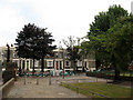
- Clicking on the map will re-center to the selected point.
- The higher the marker number, the further away the image location is from the centre of the postcode.
Image Listing (153 Images Found)
Images are licensed for reuse under creativecommons.org/licenses/by-sa/2.0
Image
Details
Distance
1
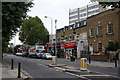
Southwark Park Road
A small parade of shops with flats above located between and opposite Reverdy Road and Alma Grove. A street cleaner can be seen going about his lonely business.
Image: © Martin Addison
Taken: 22 Oct 2010
0.04 miles
2
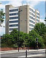
Former Aylwin School, Southwark Park Road
By Mayorcas & Guest, 1965. The concrete looks in good nick.
Now a Harris academy.
Image: © Stephen Richards
Taken: 27 May 2013
0.05 miles
3
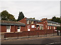
Southwark Age Concern
On Southwark Park Road.
Image: © David Anstiss
Taken: 25 Sep 2011
0.06 miles
4
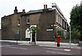
Church Cottage
Located on the corner of Reverdy Road, at the junction with Southwark Park Road, this house seems to have had some repairs to its walls in the past. The name 'Church Cottage' on the lintel above the door is just visible through a layer of cream paint. I have been unable to ascertain whether there was a link with the nearby St. Annes church, the current vicarage of which is located on Thorburn Square.
Image: © Martin Addison
Taken: 22 Oct 2010
0.07 miles
5
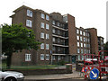
William Rushbrooke House
One of the five-storey blocks of housing making up the Eveline Lowe Estate in Bermondsey. This one faces Linsey Street.
Image: © Stephen Craven
Taken: 1 Jun 2011
0.07 miles
6
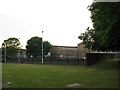
Play area near Linsey Street
The play area consists of some open grass, and an enclosed clay-surfaced area currently used as a basketball court.
Image: © Stephen Craven
Taken: 1 Jun 2011
0.09 miles
7
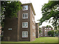
Helen Taylor House
One of the blocks of housing making up the Eveline Lowe Estate in Bermondsey. This one has four storeys and faces Linsey Street.
Image: © Stephen Craven
Taken: 1 Jun 2011
0.09 miles
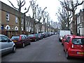
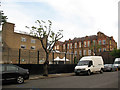
9
Southern end of Linsey Street
The junction of Linsey Street with Southwark Park Road has been closed to traffic, and a small pedestrianised area formed.
Image: © Stephen Craven
Taken: 1 Jun 2011
0.10 miles
10
Alma School (2)
Alma Primary School, consisting of two blocks: the one further away in this photo from Linsey Street is a six-storey brick building typical of London schools of the late 19th century, with a newer block to the north.
Image: © Stephen Craven
Taken: 1 Jun 2011
0.11 miles