IMAGES TAKEN NEAR TO
Eveline Lowe Estate, LONDON, SE16 3SR
Introduction
This page details the photographs taken nearby to Eveline Lowe Estate, SE16 3SR by members of the Geograph project.
The Geograph project started in 2005 with the aim of publishing, organising and preserving representative images for every square kilometre of Great Britain, Ireland and the Isle of Man.

There are currently over 7.5m images from over14,400 individuals and you can help contribute to the project by visiting https://www.geograph.org.uk
Image Map
Images are licensed for reuse under creativecommons.org/licenses/by-sa/2.0
Notes
- Clicking on the map will re-center to the selected point.
- The higher the marker number, the further away the image location is from the centre of the postcode.
Image Listing (140 Images Found)
Images are licensed for reuse under creativecommons.org/licenses/by-sa/2.0
Image
Details
Distance
1
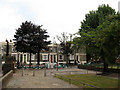
Southern end of Linsey Street
The junction of Linsey Street with Southwark Park Road has been closed to traffic, and a small pedestrianised area formed.
Image: © Stephen Craven
Taken: 1 Jun 2011
0.03 miles
2
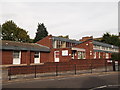
Southwark Age Concern
On Southwark Park Road.
Image: © David Anstiss
Taken: 25 Sep 2011
0.03 miles
3
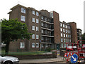
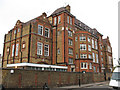
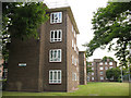
William Rushbrooke House
One of the five-storey blocks of housing making up the Eveline Lowe Estate in Bermondsey. This one faces Linsey Street.
Image: © Stephen Craven
Taken: 1 Jun 2011
0.03 miles
4
Alma School (2)
Alma Primary School, consisting of two blocks: the one further away in this photo from Linsey Street is a six-storey brick building typical of London schools of the late 19th century, with a newer block to the north.
Image: © Stephen Craven
Taken: 1 Jun 2011
0.04 miles
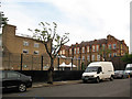
5
Alma School (1)
Alma Primary School, a six-storey brick building typical of London schools of the late 19th century.
This photo shows the side facing Alexis Street.
Image: © Stephen Craven
Taken: 1 Jun 2011
0.04 miles
7
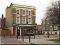
The Queen Victoria, Bermondsey
A view across Southwark Park Road from Macks Road. The junction is with Monnow Road. The pub is also shown in Image
Image: © Derek Harper
Taken: 9 Feb 2011
0.07 miles
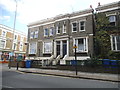
9
Helen Taylor House
One of the blocks of housing making up the Eveline Lowe Estate in Bermondsey. This one has four storeys and faces Linsey Street.
Image: © Stephen Craven
Taken: 1 Jun 2011
0.07 miles
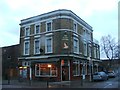
10
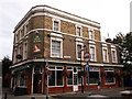
The Queen Victoria, public house Bermondsey
On the junction of Southwark Park Road (in front) and Monnow Road (on the right).
Image: © David Anstiss
Taken: 25 Sep 2011
0.07 miles