IMAGES TAKEN NEAR TO
Almond Road, LONDON, SE16 3LR
Introduction
This page details the photographs taken nearby to Almond Road, SE16 3LR by members of the Geograph project.
The Geograph project started in 2005 with the aim of publishing, organising and preserving representative images for every square kilometre of Great Britain, Ireland and the Isle of Man.

There are currently over 7.5m images from over14,400 individuals and you can help contribute to the project by visiting https://www.geograph.org.uk
Image Map
Images are licensed for reuse under creativecommons.org/licenses/by-sa/2.0
Notes
- Clicking on the map will re-center to the selected point.
- The higher the marker number, the further away the image location is from the centre of the postcode.
Image Listing (118 Images Found)
Images are licensed for reuse under creativecommons.org/licenses/by-sa/2.0
Image
Details
Distance
1
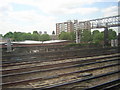
Trackside scenery, Bermondsey
This area of London is characterised by a mix of light industry and blocks of flats. The roof in the foreground is actually that of the Church of England Records Centre, although it could just as easily be a small factory.
Image: © Christopher Hilton
Taken: 19 May 2011
0.02 miles
2
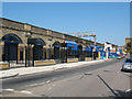
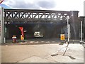
Raymouth Road arches restored (3)
One of three photos on completion of work by Network Rail to refurbish the arches under the London-Greenwich railway viaduct before re-letting them for commercial use. Formerly there were a number of businesses operating here, mainly vehicle maintenance. See Image for a 2007 view, and Image for renovation in progress.
This photo is taken from near the junction of Raymouth Road and Aspinden Road.
Image: © Stephen Craven
Taken: 2 Jun 2011
0.02 miles
3
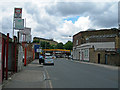
Raymouth Road, SE16
Looking towards Southwark Park Road.
Image: © Danny P Robinson
Taken: 15 Jun 2007
0.03 miles
4
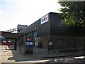
FedEx depot, Bermondsey
The depot is on Galleywall Road; the railway viaduct into London Bridge is in the background.
Image: © Stephen Craven
Taken: 21 May 2011
0.03 miles
7
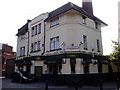
Raymouth Tavern (site of) 302, Southwark Park Road, Rotherhithe, London, SE16
Built at the junction with Raymouth Road and first recorded in 1873 - I do not know when it ceased trading as a pub. Behind the 'for sale' sign is nice, clean brickwork that for many years was covered by a large sign bearing "THE RAYMOUTH TAVERN COURAGE". The sign itself replaced a very large lamp and the name of the pub was on a large masonry plinth on the roof above it.
Image: © Chris Lordan
Taken: 12 Oct 2009
0.04 miles
8
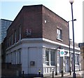
Ancient Forresters pub. 282, Galleywall Road, Rotherhithe, London, SE16
At the junction with Southwark Park Road and first recorded in 1866. In 1925 Dr. Alfred Salter, in a speech in Parliament before the Royal Commission on licensing stated "the previous year, the people of Bermondsey spent £1,335,000 on alcohol but only £182,500 on milk and £230,000 on bread".
Image: © Chris Lordan
Taken: 29 Aug 2007
0.05 miles
9
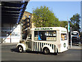
Old ice cream van
A vintage vehicle (registration DSL 844 implying pre-1962), but in good condition.
Image: © Stephen Craven
Taken: 16 Apr 2014
0.05 miles
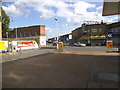
10
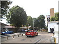
Petrol station on the corner of Drummond Road
Image: © David Howard
Taken: 6 Aug 2017
0.05 miles