IMAGES TAKEN NEAR TO
Spa Road, LONDON, SE16 3FG
Introduction
This page details the photographs taken nearby to Spa Road, SE16 3FG by members of the Geograph project.
The Geograph project started in 2005 with the aim of publishing, organising and preserving representative images for every square kilometre of Great Britain, Ireland and the Isle of Man.

There are currently over 7.5m images from over14,400 individuals and you can help contribute to the project by visiting https://www.geograph.org.uk
Image Map
Images are licensed for reuse under creativecommons.org/licenses/by-sa/2.0
Notes
- Clicking on the map will re-center to the selected point.
- The higher the marker number, the further away the image location is from the centre of the postcode.
Image Listing (282 Images Found)
Images are licensed for reuse under creativecommons.org/licenses/by-sa/2.0
Image
Details
Distance
1
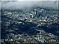
The City of London from the air
Looking over Bermondsey, Tower Bridge, St Paul's Cathedral, The Shard, The Walkie Talkie building (20 Fenchurch Street) and The Gherkin (30 St Mary Axe) are all visible. Taken from a Heathrow bound flight from Glasgow.
Image: © Thomas Nugent
Taken: 18 Mar 2014
0.03 miles
2
Neckinger Estate TRA hall
I presume TRA stands for Tenants and Residents Association.
Image: © Stephen Craven
Taken: 7 Oct 2013
0.05 miles
3
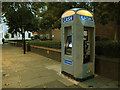
Cash Zone, Spa Road
A contemporary cash machine-cum-public-telephone on the street. Unlike the cashpoints in banks, machines such as this charge (typically £1.50) for a withdrawal. But that's no more than the cost of a bus fare into the city.
Image: © Stephen Craven
Taken: 7 Oct 2013
0.05 miles
6
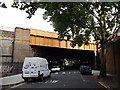
Spa Road Railway Bridge
Spa Road leads from Grange Road towards Thurland Road.
It passes under a Grade II listed railway bridge, carrying many railway lines from South Bermondsey, New Cross, New Cross Gate and Deptford towards London Bridge (and Cannon Street).
See http://www.britishlistedbuildings.co.uk/en-471352-railway-bridge-bermondsey for more details about the bridge.
Image: © David Anstiss
Taken: 25 Sep 2011
0.08 miles
7
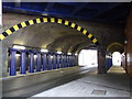
Under Spa Road Railway Bridge
Spa Road leads from Thurland Road towards Grange Road.
It passes under a Grade II listed railway bridge, carrying many railway lines from South Bermondsey, New Cross, New Cross Gate and Deptford towards London Bridge (and Cannon Street).
See http://www.britishlistedbuildings.co.uk/en-471352-railway-bridge-bermondsey for more details about the bridge.
Image: © David Anstiss
Taken: 25 Sep 2011
0.08 miles
8
Marine Street railway bridge
One of several streets crossed by the original London and Greenwich railway viaduct (and its later widenings). The height restriction is 4.2 metres, but there appears to be a bollard at the far end restricting it in practice to cycle and pedestrian use.
See Image for a photo of the opposite end.
Image: © Stephen Craven
Taken: 7 Oct 2013
0.08 miles
9
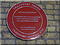
Spa Road railway bridge - plaque
The original line crossing the road here was built in 1836 by Colonel Landmann, engineer of the London and Greenwich Railway. As one of the two surviving bridges from London's first railway line, the bridge is grade 2 listed and was refurbished in 2011. The plaque marks the station which sat on the viaduct above, for a short time in 1836. For context, see Image
Image: © Stephen Craven
Taken: 7 Oct 2013
0.08 miles
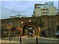
10
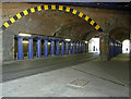
Bridge, Spa Road
Carrying the railway, and boasting a fine array of cast-iron Greek Doric columns. The whole viaduct was by G. Landmann, 1833-36, for the London and Greenwich Railway.
Image: © Stephen Richards
Taken: 27 May 2013
0.08 miles