IMAGES TAKEN NEAR TO
Rossetti Road, LONDON, SE16 3EA
Introduction
This page details the photographs taken nearby to Rossetti Road, SE16 3EA by members of the Geograph project.
The Geograph project started in 2005 with the aim of publishing, organising and preserving representative images for every square kilometre of Great Britain, Ireland and the Isle of Man.

There are currently over 7.5m images from over14,400 individuals and you can help contribute to the project by visiting https://www.geograph.org.uk
Image Map
Images are licensed for reuse under creativecommons.org/licenses/by-sa/2.0
Notes
- Clicking on the map will re-center to the selected point.
- The higher the marker number, the further away the image location is from the centre of the postcode.
Image Listing (109 Images Found)
Images are licensed for reuse under creativecommons.org/licenses/by-sa/2.0
Image
Details
Distance
1
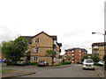
Stubbs Drive, South Bermondsey
The eastern end of a large housing estate.
Image: © Stephen Craven
Taken: 9 May 2013
0.04 miles
2
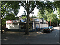
Dan's cafe
A refreshment facility on the corner of Galleywall Road and Hyson Road.
Image: © Stephen Craven
Taken: 21 May 2011
0.07 miles
3
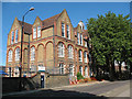
Southwark Park School
A typical late-19th century 3-storey primary school on Galleywall Road. See also Image
Image: © Stephen Craven
Taken: 21 May 2011
0.07 miles
4
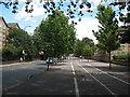
Cycle path alongside Rotherhithe New Road
This particularly wide pavement has been put to good use as a two-way segregated cycle track. Compare with the same road further west Image
Image: © Stephen Craven
Taken: 18 Jul 2009
0.07 miles
5
Bermondsey Connect2 bridge - northern approach
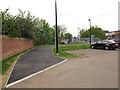
A new length of shared use path at the eastern end of Stubbs Drive.
Image: © Stephen Craven
Taken: 9 May 2013
0.07 miles
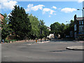
6
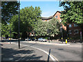
Rotherhithe New Road
Looking west from the junction with Ilderton Road, after remodelling in 2010.
Image: © Stephen Craven
Taken: 21 May 2011
0.08 miles
7
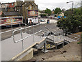
Bermondsey Connect2 bridge - steps
The steps from Rotherhithe New Road to the bridge were still under construction in May 2013 although the bridge itself was opened in January.
Image: © Stephen Craven
Taken: 9 May 2013
0.08 miles
8
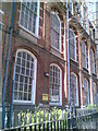
Galleywall Road School (detail)
A standard School Board for London design from the early 20th century, now used by Southwark Council as a "spare" school - a site available to accommodate other schools whilst their buildings are refurbished, and so forth.
Image: © Helena Hilton
Taken: 9 Apr 2008
0.08 miles
9
Junction on Rotherhithe New Road
The junction with Ilderton Road, after remodelling in 2010. Compare Image
Image: © Stephen Craven
Taken: 21 May 2011
0.08 miles
10
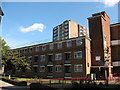
Barlow House
One of several similar housing blocks comprising the Rennie Estate. This one faces Galleywall Road. See Image for some history including an explanation of the name.
Image: © Stephen Craven
Taken: 21 May 2011
0.08 miles