IMAGES TAKEN NEAR TO
Verney Road, LONDON, SE16 3DH
Introduction
This page details the photographs taken nearby to Verney Road, SE16 3DH by members of the Geograph project.
The Geograph project started in 2005 with the aim of publishing, organising and preserving representative images for every square kilometre of Great Britain, Ireland and the Isle of Man.

There are currently over 7.5m images from over14,400 individuals and you can help contribute to the project by visiting https://www.geograph.org.uk
Image Map
Images are licensed for reuse under creativecommons.org/licenses/by-sa/2.0
Notes
- Clicking on the map will re-center to the selected point.
- The higher the marker number, the further away the image location is from the centre of the postcode.
Image Listing (82 Images Found)
Images are licensed for reuse under creativecommons.org/licenses/by-sa/2.0
Image
Details
Distance
1
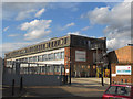
Action House, Sandgate Street, North Peckham
The offices of the charity Action for Blind People.
Image: © Stephen Craven
Taken: 22 Jul 2015
0.02 miles
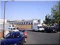
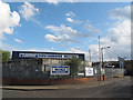
3
Sandgate Street Industrial Estate
The man with a bicycle was locking the gates on his way out at the end of a working day.
Image: © Stephen Craven
Taken: 22 Jul 2015
0.05 miles
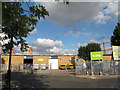
4
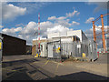
Entrance to Marchant Trading Estate
The security guard appeared from his hut as I took the photo. He declined me entry to the private roads of the industrial estate (fair enough, with no appointment) but also took some convincing that I was committing no offence by taking a photo from the public road outside.
Image: © Stephen Craven
Taken: 22 Jul 2015
0.08 miles
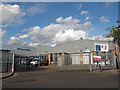
5
Southwark Metals
A metal recycling company on the Sandgate Street Industrial Estate Image
Image: © Stephen Craven
Taken: 22 Jul 2015
0.08 miles
6
Yodel, Sandgate Street depot
A parcel delivery company on the Sandgate Street Industrial Estate Image
Image: © Stephen Craven
Taken: 22 Jul 2015
0.09 miles
7
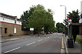
Southwark: Rotherhithe New Road
Looking northeast
Image: © Dr Neil Clifton
Taken: 5 Jul 2012
0.09 miles
8
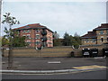
Apples & Pears pub (site of). Verney Way, Rotherhithe, London, SE16
The pub would have been about where the refuse bins now stand. Built about the late 1960's, the same time as the original Bonamy Estate. In the background can be seen part of the new Bonamy Estate. The first was built either side of Rotherhithe New Road, consequently half was in Bermondsey. Rotherhithe had :- Barkis : Boythorne : Egan : Joram : Meltham : Starklieigh : Willet and Witherfield - all 'Ways'. I do not know where any of the names came from but I do know that the existing estate have the dwellings in a 'Close' and not a 'Way'. Meltham has a golf course and all the new names are of golf courses. The estate was demolished early 1990's and I believe it suffered a great deal of 'concrete cancer'. The pub was totally without character and lasted the same time as the original estate.
Image: © Chris Lordan
Taken: 27 Oct 2009
0.10 miles
9
Enterprise Car Rental, Sandgate Street, North Peckham
One of several Enterprise depots in South London.
Image: © Stephen Craven
Taken: 22 Jul 2015
0.11 miles
10
Howdens Joinery, Ruby Street
Part of the Sandgate Street Industrial Estate.
Image: © Stephen Craven
Taken: 22 Jul 2015
0.11 miles