IMAGES TAKEN NEAR TO
Gomm Road, LONDON, SE16 2TY
Introduction
This page details the photographs taken nearby to Gomm Road, SE16 2TY by members of the Geograph project.
The Geograph project started in 2005 with the aim of publishing, organising and preserving representative images for every square kilometre of Great Britain, Ireland and the Isle of Man.

There are currently over 7.5m images from over14,400 individuals and you can help contribute to the project by visiting https://www.geograph.org.uk
Image Map
Images are licensed for reuse under creativecommons.org/licenses/by-sa/2.0
Notes
- Clicking on the map will re-center to the selected point.
- The higher the marker number, the further away the image location is from the centre of the postcode.
Image Listing (206 Images Found)
Images are licensed for reuse under creativecommons.org/licenses/by-sa/2.0
Image
Details
Distance
1
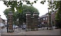
Gomm Gates (4 of 6) to Southwark Park, Rotherhithe, London, SE16
Situated where The Drive and Gomm Road meet. Named after the Lord of the Manor of Rotherhithe, Field Marshall Sir William Maynard Gomm GCB (1784 - 1875), who sold some of his land for the construction of the park. Appear to be the only set of the 6 gates that have remained as constructed.
Image: © Chris Lordan
Taken: 30 Sep 2009
0.04 miles
2
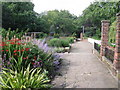
Ada Salter Rose Garden. Southwark Park, Rotherhithe, London, SE16
Opened in 1936 and named after Ada Salter (1869-1942), wife of Dr Alfred Salter (1873-1945), the "sixpenny doctor". In 1902 they had a daughter, Joyce, and they debated whether to stay in Bermondsey or move to Kent for the cleaner air. They chose Bermondsey. Joyce died in 1910 of scarlet fever.
Image: © Chris Lordan
Taken: 30 Sep 2009
0.04 miles
3
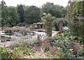
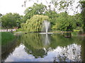
Trees in Southwark Park
These same young trees can be seen in Neil Clifton's photo from four years earlier: Image
Image: © Stephen Craven
Taken: 18 Nov 2011
0.06 miles
4
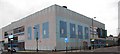
Rotherhithe Swimming Baths, Lower Road, SE16
Located at the junction with Gomm Road. The original Slippers Baths was built in 1801 and contained 2 good size pools and 65 private baths. In 1887 Mrs Carr-Gomm presented the lease hold of the site to the parish of Rotherhithe. That building was demolished in 1963. The existing building was opened in 1965 before it was finally completed. This was instigated by Councillor Lucy Brown so that the crest of Bermondsey Council and not Southwark Council could be displayed on the building. In the 1990's the name was changed to "Seven Islands" after the small islands formed by the cleaning out of the Mill Pond (mid 1700's) some hundreds of yards behind the baths. In 1875 and at the end of the building in Gomm Road,was a fire station.
Image: © Chris Lordan
Taken: 23 Sep 2009
0.06 miles
5
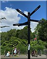
Fingerpost, Southwark Park
The destination, in every direction, is 'Onward': an invitation to explore.
Photo number 7884747.
Image: © Robin Stott
Taken: 26 May 2024
0.07 miles
7
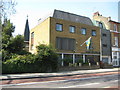
Rotherhithe: Svenska Sj?manskyrkan...
...or Swedish Seamen's Church.
The church is at 120 Lower Road, Rotherhithe, SE16, and would have been built originally to serve the needs of Swedish seamen working on ships using the former Surrey Commercial Docks. It has 34 guestrooms. The Church's website is here http://www.londonsvenskar.com/index.php?option=content&task=view&id=35
The spire towards the rear merits its own symbol on the Ordnance Survey 1:50,000 scale mapping.
Image: © Nigel Cox
Taken: 18 Apr 2010
0.08 miles
8
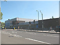
Seven Islands Leisure Centre
The leisure centre is on Lower Road, Rotherhithe. The traffic lights are at the junction with Surrey Quays Road.
Image: © Stephen Craven
Taken: 22 May 2010
0.08 miles
9
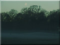
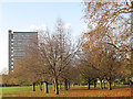
Southwark Park - moon over the mist
The waning moon above trees on a misty morning.
Image: © Stephen Craven
Taken: 20 Jan 2014
0.08 miles