IMAGES TAKEN NEAR TO
St. Helena Road, LONDON, SE16 2QX
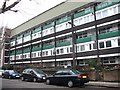
Introduction
This page details the photographs taken nearby to St. Helena Road, SE16 2QX by members of the Geograph project.
The Geograph project started in 2005 with the aim of publishing, organising and preserving representative images for every square kilometre of Great Britain, Ireland and the Isle of Man.

There are currently over 7.5m images from over14,400 individuals and you can help contribute to the project by visiting https://www.geograph.org.uk
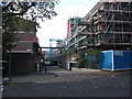
Image Map
Images are licensed for reuse under creativecommons.org/licenses/by-sa/2.0
Notes
- Clicking on the map will re-center to the selected point.
- The higher the marker number, the further away the image location is from the centre of the postcode.
Image Listing (188 Images Found)
Images are licensed for reuse under creativecommons.org/licenses/by-sa/2.0
Image
Details
Distance
1
Site of Royal William public house
The Royal William public house was at 15 St Helena Road, Rotherhithe, SE16 from 1852 to 1865. The site, and a much larger area, later became the St Helena Tea Gardens which incorporated the St Helena Tavern. Possibly the Royal William was demolished for this project or was left intact and renamed the St Helena tavern.
Image: © Chris Lordan
Taken: 20 Feb 2011
0.02 miles
2
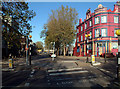
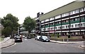
Rotherhithe Old Road SE16
View from the southern end. On the right is the London Outreach Centre; "John 3:16 For God so loved the world". Surrey Quays underground station is a couple of hundred yards to the north.
Image: © Philip Talmage
Taken: 18 Nov 2005
0.05 miles
3
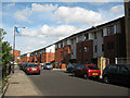
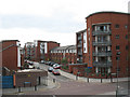
New housing on Eugenia Road
The low-rise housing on the south side of the road was built c. 2006.
Image: © Stephen Craven
Taken: 20 Aug 2009
0.05 miles
4
St Helena Tavern (site of) 23, St Helena Road, Rotherhithe, London, SE16
It stood opposite and just east of Luxford Street at the junction with Eugenia Road (Eugenia Road used to run into St Helena Road). The last pub was built or first recorded in 1787 and closed in 1966. However, in the mid 1750's, on or very close to the site stood the famous St Helena Tea Gardens - a respectable general purpose entertainment area that boasted of trees, ponds and two Chinese pavilions. Said at the time to be bounded by hay fields and hills forming a range from east to west. Nowadays it feels that the place is bounded by a scenic railway due to the small hills called roads. Near the tea gardens was a site where the Rotherhithe Volunteers trained.
Image: © Chris Lordan
Taken: 4 Nov 2009
0.05 miles
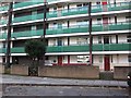
5
Sir Garnet Wolseley pub (site of) 6, Warndon Street, Rotherhithe, London, SE16
The pub would have stood on the entrance where the estate road has been constructed, at the then junction with Silverlock Street. The pub opened in 1878 and closed in 1971. Building on the left is McIntosh House and that on the right is Westlake House. Westlake Road ran off Silverlock Street and both terminated in Silwood Street.
Image: © Chris Lordan
Taken: 4 Nov 2009
0.06 miles
6
Island Road, Rotherhithe
A recent building development to the west of Oldfield Grove, viewed from the railway footbridge.
Image: © Stephen Craven
Taken: 27 Apr 2010
0.06 miles
7
St Helena Road (part), Rotherhithe, London, SE16
Did at one time extend to Silwood Street. It was about this location in the early 1700's where the famous St Helena Tea Gardens stood. It was built on the periphery of the events concerning the Mill Pond and described as a general purpose entertainment area. It comprised of two fish ponds with yew trees forming alcoves, two Chinese pavilions surrounded by weeping willows and similar. Nearby was the parade ground where the Rotherhithe Volunteers trained.
Image: © Chris Lordan
Taken: 23 Sep 2009
0.07 miles
8
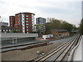
New track layout at Deptford Road Junction
The junction was where the former line to Peckham met the line from New Cross on the former East London Line. The Peckham tracks were lifted as early as 1913 though one track to the west side of New Cross Gate survived until 1964 [source: London Railway Atlas by Joe Brown]. As part of the redevelopment of the route for London Overground, a stub of track was laid (left foreground) to permit the Peckham route to be reinstated at a later date. The track at the far side of the formation is the northbound track from New Cross Gate that now uses a new flyover - see Image Behind it is a ramp to the new footbridge.
Image: © Stephen Craven
Taken: 27 Apr 2010
0.07 miles
10
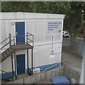
Network Rail establishment
Signed 'East London Line Infrastructure Maintenance Facility'. The view is from the ramp up to the footbridge that connects Oldfield Grove and Trundley's Terrace.
Image: © Robin Stott
Taken: 29 Aug 2024
0.08 miles