IMAGES TAKEN NEAR TO
Drummond Road, LONDON, SE16 2JY
Introduction
This page details the photographs taken nearby to Drummond Road, SE16 2JY by members of the Geograph project.
The Geograph project started in 2005 with the aim of publishing, organising and preserving representative images for every square kilometre of Great Britain, Ireland and the Isle of Man.

There are currently over 7.5m images from over14,400 individuals and you can help contribute to the project by visiting https://www.geograph.org.uk
Image Map
Images are licensed for reuse under creativecommons.org/licenses/by-sa/2.0
Notes
- Clicking on the map will re-center to the selected point.
- The higher the marker number, the further away the image location is from the centre of the postcode.
Image Listing (142 Images Found)
Images are licensed for reuse under creativecommons.org/licenses/by-sa/2.0
Image
Details
Distance
2

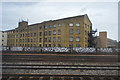
Trackside in Bermondsey: the Biscuit Factory
The Biscuit Factory, formerly known as the Tower Bridge Business Complex, is a complex of office and manufacturing units sited in the old Peek Frean biscuit factory, the latter having been a major employer in Bermondsey for decades. The Biscuit Factory houses at least one TV production company and British TV viewers will often see the buildings, streets and railway arches of this area as the backdrop to car chases or police stakeouts.
The graffiti "Fundin' Cuts and Corporate Sluts" is a product of the deficit-dominated atmosphere of 2010. It lasted about a week in this form before work began on covering it up. I'm no great fan of graffiti, to put it mildly, but it seems that there's a definite hierarchy of response: things like this offering political comment are targeted immediately whilst teenagers' idiot tagging can last for years.
Image: © Christopher Hilton
Taken: 14 Dec 2010
0.06 miles
5
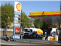
Fuel delivery
A tanker delivers to Shell's Southwark Park Road site Image
Image: © Stephen Craven
Taken: 16 Apr 2014
0.10 miles
6
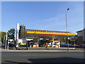
Shell filling station, Southwark Park Road
On the corner of Drummond Road.
Image: © Stephen Craven
Taken: 16 Apr 2014
0.11 miles
7
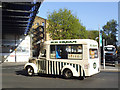
Old ice cream van
A vintage vehicle (registration DSL 844 implying pre-1962), but in good condition.
Image: © Stephen Craven
Taken: 16 Apr 2014
0.11 miles
8
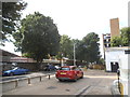
Petrol station on the corner of Drummond Road
Image: © David Howard
Taken: 6 Aug 2017
0.11 miles
9
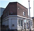
Raymouth Tavern (site of) 302, Southwark Park Road, Rotherhithe, London, SE16
Built at the junction with Raymouth Road and first recorded in 1873 - I do not know when it ceased trading as a pub. Behind the 'for sale' sign is nice, clean brickwork that for many years was covered by a large sign bearing "THE RAYMOUTH TAVERN COURAGE". The sign itself replaced a very large lamp and the name of the pub was on a large masonry plinth on the roof above it.
Image: © Chris Lordan
Taken: 12 Oct 2009
0.12 miles