IMAGES TAKEN NEAR TO
Lockwood Square, LONDON, SE16 2HY
Introduction
This page details the photographs taken nearby to Lockwood Square, SE16 2HY by members of the Geograph project.
The Geograph project started in 2005 with the aim of publishing, organising and preserving representative images for every square kilometre of Great Britain, Ireland and the Isle of Man.

There are currently over 7.5m images from over14,400 individuals and you can help contribute to the project by visiting https://www.geograph.org.uk
Image Map
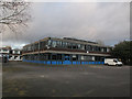
Images are licensed for reuse under creativecommons.org/licenses/by-sa/2.0
Notes
- Clicking on the map will re-center to the selected point.
- The higher the marker number, the further away the image location is from the centre of the postcode.
Image Listing (161 Images Found)
Images are licensed for reuse under creativecommons.org/licenses/by-sa/2.0
Image
Details
Distance
3
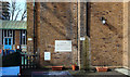
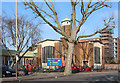
St Crispin, Bermondsey - Foundation stone
Image: © John Salmon
Taken: 4 Mar 2013
0.06 miles
4
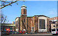
Rear of St Crispin's church, Bermondsey
For the front of this grade 2 listed former church on Southwark Park Road, see Image It was built to the designs of Thomas Ford in 1959. As of 2015 it was in use by a nursery but there was talk locally of bringing it back into use for worship.
In the foreground is a sunken multi-sports play area.
Image: © Stephen Craven
Taken: 8 Mar 2015
0.06 miles
6
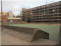
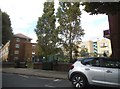
Play area on Drummonds Road, Bermondsey
A sunken multi-sports play area. Not very attractive, but functional.
Image: © Stephen Craven
Taken: 8 Mar 2015
0.07 miles
7
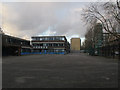
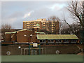
Former Southwark College, Bermondsey (4)
A view from Clements Road.
Image: © Stephen Craven
Taken: 8 Mar 2015
0.07 miles
9
Former Southwark College, Bermondsey (3)
A view from Clements Road.
Image: © Stephen Craven
Taken: 8 Mar 2015
0.08 miles
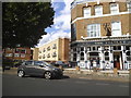
10
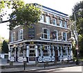
The Stanley Arms. 418, Southwark Park Road, Rotherhithe, London, SE16
Is at the junction with Stalham Street (left) and was first recorded in 1866. For many years (1960-1975), like all the pubs in the area, it was a dowdy looking building that sold alcohol. It appears that competition has brightened up such buildings. Original pub on the site was the 'Joiners Arms'.
Image: © Chris Lordan
Taken: 12 Oct 2009
0.10 miles