IMAGES TAKEN NEAR TO
Slippers Place, LONDON, SE16 2ER
Introduction
This page details the photographs taken nearby to Slippers Place, SE16 2ER by members of the Geograph project.
The Geograph project started in 2005 with the aim of publishing, organising and preserving representative images for every square kilometre of Great Britain, Ireland and the Isle of Man.

There are currently over 7.5m images from over14,400 individuals and you can help contribute to the project by visiting https://www.geograph.org.uk
Image Map
Images are licensed for reuse under creativecommons.org/licenses/by-sa/2.0
Notes
- Clicking on the map will re-center to the selected point.
- The higher the marker number, the further away the image location is from the centre of the postcode.
Image Listing (135 Images Found)
Images are licensed for reuse under creativecommons.org/licenses/by-sa/2.0
Image
Details
Distance
3
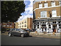
The Stanley Arms. 418, Southwark Park Road, Rotherhithe, London, SE16
Is at the junction with Stalham Street (left) and was first recorded in 1866. For many years (1960-1975), like all the pubs in the area, it was a dowdy looking building that sold alcohol. It appears that competition has brightened up such buildings. Original pub on the site was the 'Joiners Arms'.
Image: © Chris Lordan
Taken: 12 Oct 2009
0.03 miles
4
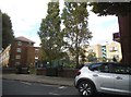
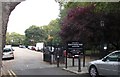
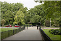
The Lodge, Southwark Park, Rotherhithe, London, SE16
Situated in The Drive junction with Southwark Park Road and in the north section of the park. The original was built on the opposite side of The Drive but demolished long before 1960. Was the home of the Parks Superintendant.
Image: © Chris Lordan
Taken: 30 Sep 2009
0.07 miles
5
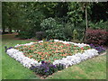
Flower Border in Southwark Park
One of several bedding displays beside Southwark Park Road.
Image: © David Anstiss
Taken: 25 Sep 2011
0.08 miles
6
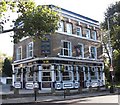
Jamaica Gates (1 of 6) to Southwark Park, Rotherhithe, London SE16
In Southwark Park Road, which until the park was opened was called Jamaica Level. It is the main entrance to the park but from at latest the early 1900s boasted only of railings whereas all the other five gates have brick columns. The park was opened 26-06-1869 at a cost of £110,393 and Queen Victoria donated two swans, Joe and Jenny, for the lake.
Image: © Chris Lordan
Taken: 30 Sep 2009
0.09 miles
7
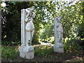
Rotherhithe Ladies
Henry Poole's Grecian ladies have returned to Rotherhithe. The ladies returned after an absence of about 35 years. Originally stood either side of the main entrance of Rotherhithe Town Hall built 1897 in Lower Road junction with Neptune Street. The Town Hall then became the library but was damaged by a German V1 rocket on 13-08-1944 and destroyed by a second V1 on 14-11-1944. The ladies (Caryatids) were removed from location and installed in the Heygate Estate in Walworth, London, SE17 - despite many verbal and written requests SE17 would not allow them back to SE16. They were eventually allowed back with the demolition of the estate and installed in Southwark Park. Unveiled Saturday 4th June 2011 by the Mayoress, Councillor Lorraine Lauder B.E.M.
Image: © Chris Lordan
Taken: 4 Jun 2011
0.09 miles
10
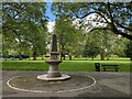
Obeliskal drinking fountain, Southwark Park
Image: © Robin Stott
Taken: 26 May 2024
0.12 miles