IMAGES TAKEN NEAR TO
Kirby Estate, Southwark Park Road, LONDON, SE16 2EE
Introduction
This page details the photographs taken nearby to Kirby Estate, Southwark Park Road, SE16 2EE by members of the Geograph project.
The Geograph project started in 2005 with the aim of publishing, organising and preserving representative images for every square kilometre of Great Britain, Ireland and the Isle of Man.

There are currently over 7.5m images from over14,400 individuals and you can help contribute to the project by visiting https://www.geograph.org.uk
Image Map
Images are licensed for reuse under creativecommons.org/licenses/by-sa/2.0
Notes
- Clicking on the map will re-center to the selected point.
- The higher the marker number, the further away the image location is from the centre of the postcode.
Image Listing (330 Images Found)
Images are licensed for reuse under creativecommons.org/licenses/by-sa/2.0
Image
Details
Distance
1
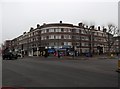
Housing and shops, Jamaica Road SE16
At the junction with Southwark Park Road
Image: © Robin Sones
Taken: 26 Feb 2013
0.02 miles
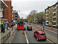
2
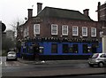
The Boatman, Jamaica Road SE16
At the junction with Prospect Street
Image: © Robin Sones
Taken: 26 Feb 2013
0.03 miles
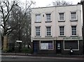
4
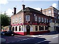
The Boatman, formerly the Royal George pub
At 234 Jamaica Road, junction with Prospect Street, Rotherhithe, SE16. Built about 1851 several of the licensees between 1881 and 1944 had the surname Boatman https://pubwiki.co.uk/LondonPubs/Rotherhithe/RoyalGeorge.shtml which may account for the new name.
Update: Pub was demolished at some point between October 2016 and March 2017, replaced by Boatman House, a four-storey apartment block with shop premises on the ground floor (Streetview).
Image: © Chris Lordan
Taken: 31 Jul 2007
0.03 miles
5
Jamaica Road SE16
At the junction with West Lane
Image: © Robin Sones
Taken: 26 Feb 2013
0.04 miles
8
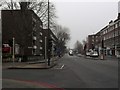
A200, Jamaica Road, SE16
Heading towards London Bridge. Flats of the Pynfolds Estate are on the right.
Image: © Robin Webster
Taken: 6 Apr 2019
0.05 miles
9
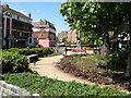
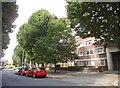
Garden on West Lane
A small public garden on the east side of West Lane, containing the war memorial Image
Image: © Stephen Craven
Taken: 21 May 2011
0.05 miles
10
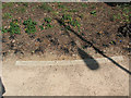
They shall not grow old...
A familiar text, inscribed on kerbstones in the small public garden on the east side of West Lane, containing the war memorial. For context, see Image
Image: © Stephen Craven
Taken: 21 May 2011
0.05 miles