IMAGES TAKEN NEAR TO
Mossington Gardens, LONDON, SE16 2DZ
Introduction
This page details the photographs taken nearby to Mossington Gardens, SE16 2DZ by members of the Geograph project.
The Geograph project started in 2005 with the aim of publishing, organising and preserving representative images for every square kilometre of Great Britain, Ireland and the Isle of Man.

There are currently over 7.5m images from over14,400 individuals and you can help contribute to the project by visiting https://www.geograph.org.uk
Image Map
Images are licensed for reuse under creativecommons.org/licenses/by-sa/2.0
Notes
- Clicking on the map will re-center to the selected point.
- The higher the marker number, the further away the image location is from the centre of the postcode.
Image Listing (154 Images Found)
Images are licensed for reuse under creativecommons.org/licenses/by-sa/2.0
Image
Details
Distance
2
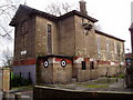
Clare College Mission
Situated in Dilston Grove, Rotherhithe and built in 1912 and a pioneer building being constructed of concrete on a bed of concrete. The "bed" was to prevent land slip as suffered by its predecessor. The designer was also responsible for the design of the original Wembley Stadium.
Image: © Chris Lordan
Taken: 30 Mar 2008
0.04 miles
3
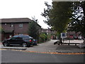
Sir William Gomm pub (site of) 44, Abbeyfield Road, London SE16
Was on the left of the junction with Mossington Street, first recorded in 1832 and closed in 1978. It was a three-storeyed square building and named after the Lord of the Manor of Rotherhithe, Field Marshall Sir William Maynard Gomm GCB (1784 to 1875). He created a record that will never be broken in this country i.e. 81 years' continuous service in the army. This was the second pub so named in the area; the first was close to the inland side of the Greenland Dock - 1857 to 1873 -but was demolished when the Port of London Authority extended their land.
Image: © Chris Lordan
Taken: 19 Oct 2009
0.04 miles
5
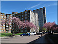
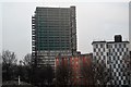
Nelldale Road
Looking away from the junction with Raymouth Road, with Maydew House Image in the background.
Image: © Stephen Craven
Taken: 2 May 2013
0.05 miles

7
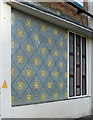
Detail of Abbeyfield Estate, Nelldale Road
A typical snippet of 1960s design on Bradley House.
Image: © Stephen Richards
Taken: 26 May 2013
0.05 miles
8
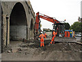
Renovating the Greenwich viaduct
In 2010 a number of railway arches alongside Raymouth Road that had previously been used by a commercial vehicle repair business were vacated, and renovated by Network Rail's contractors before being put up for rental again.
The foreman kindly allowed me far enough in to the site to take a couple of photos (I could not go further without the necessary permit, safety gear etc.)
This viaduct, still the longest brick railway viaduct in the world, opened in 1836. See http://en.wikipedia.org/wiki/London_and_Greenwich_Railway for its history.
Image: © Stephen Craven
Taken: 20 Jul 2010
0.06 miles
10
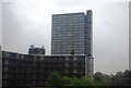
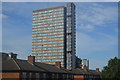
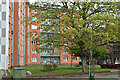
Maydew House, Abbeyfield Rd, Southwark on a very wet day
Image: © N Chadwick
Taken: 8 May 2010
0.06 miles