IMAGES TAKEN NEAR TO
Pedworth Gardens, LONDON, SE16 2DX
Introduction
This page details the photographs taken nearby to Pedworth Gardens, SE16 2DX by members of the Geograph project.
The Geograph project started in 2005 with the aim of publishing, organising and preserving representative images for every square kilometre of Great Britain, Ireland and the Isle of Man.

There are currently over 7.5m images from over14,400 individuals and you can help contribute to the project by visiting https://www.geograph.org.uk
Image Map
Images are licensed for reuse under creativecommons.org/licenses/by-sa/2.0
Notes
- Clicking on the map will re-center to the selected point.
- The higher the marker number, the further away the image location is from the centre of the postcode.
Image Listing (161 Images Found)
Images are licensed for reuse under creativecommons.org/licenses/by-sa/2.0
Image
Details
Distance
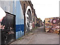
2
Entrance to Southwark Park British rail station
Situated in Rotherhithe New Road at the junction with Corbetts Passage. The entrance is beneath the bridge and two windows of the ticket office etc. in Corbetts Passage. Opened in 1902, closed as a war economy in 1915 and never re opened.
Image: © Chris Lordan
Taken: 7 Mar 2007
0.05 miles
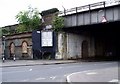
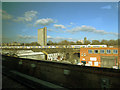
3
Bridges Over Rotherhithe New Road
These bridges carry the railway lines from London Bridge station with services to much of south London, Kent and the south coast.
Image: © Martin Addison
Taken: 22 Oct 2010
0.05 miles
5
Southwark Park Station
The remains of Southwark Park Station, closed in 1915. Taken from Corbetts Lane, looking towards Rotherhithe New Road.
Image: © Robert Eva
Taken: 10 Jan 2016
0.05 miles
6
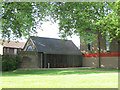
Dilston Grove annexe building
One of a pair of buildings currently known as Dilston Grove (after the name of a local street that no longer exists since post-war redevelopment). The site is now off Abbeyfield Road on the edge of Southwark Park.
This later building is an annexe to the former church Image and has been fitted with the same polycarbonate window protection as the church.
Image: © Stephen Craven
Taken: 22 May 2015
0.06 miles
7
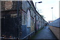
Corbetts Passage, Rotherhithe, London, SE16
Off Rotherhithe New Road, opposite Raymouth Road and runs into Silwood Street. Many will know it's named after the Canadian murderer, William Corbett, who was hanged on 04-04-1764 for two murders in Cherry Garden Street, Bermondsey, SE1. His body was hung on a gibbet in Rotherhithe New Road (then Deptford Road). What may not be known is on the railway lines above, about 1839 the worlds first signal box was erected. Far end of the image can be seen Southwark Park British Rail Station (1902 to 1915).
Image: © Chris Lordan
Taken: 23 Sep 2009
0.06 miles
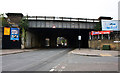
8
Electrostar at South Bermondsey
Eight of the ten coaches of this train can be seen as it crosses Rotherhithe New Road.
Image: © Stephen Craven
Taken: 6 Feb 2015
0.06 miles
9

Dilston Grove (former church)
One of a pair of buildings currently known as Dilston Grove (after the name of a local street that no longer exists since post-war redevelopment). The site is now off Abbeyfield Road on the edge of Southwark Park.
This older building dates from 1912. It was originally known as the Clare College Mission (being founded by graduates of that Cambridge college) and later as the Church of the Epiphany. The architects were John Simpson & Maxwell Ayrton, and it is notable for being one of the earliest reinforced concrete (then known as ferro-concrete) churches in the UK. Now listed grade 2 (list entry number 1385919) mainly for that reason.
It was declared redundant as a church c.1950, and converted to artists' studios in the 1960's. Since 2010 it has been used as a single empty space for large scale art installations.
Image: © Stephen Craven
Taken: 22 May 2015
0.06 miles
10
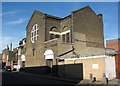
St Gertrude's Church, 1, Debnams Road, Rotherhithe, London, SE16
A Roman Catholic church built in 1902 and said to have been built to cater for the vast number of Irish labourers who came to the area to assist in the building of the railway on the nearby viaduct. That said, the viaduct was built or started about 1832ish.
Image: © Chris Lordan
Taken: 27 Oct 2009
0.06 miles