IMAGES TAKEN NEAR TO
Raymouth Road, LONDON, SE16 2DB
Introduction
This page details the photographs taken nearby to Raymouth Road, SE16 2DB by members of the Geograph project.
The Geograph project started in 2005 with the aim of publishing, organising and preserving representative images for every square kilometre of Great Britain, Ireland and the Isle of Man.

There are currently over 7.5m images from over14,400 individuals and you can help contribute to the project by visiting https://www.geograph.org.uk
Image Map
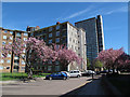
Images are licensed for reuse under creativecommons.org/licenses/by-sa/2.0
Notes
- Clicking on the map will re-center to the selected point.
- The higher the marker number, the further away the image location is from the centre of the postcode.
Image Listing (144 Images Found)
Images are licensed for reuse under creativecommons.org/licenses/by-sa/2.0
Image
Details
Distance
1
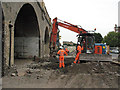
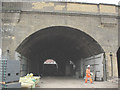
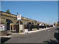
Renovating the Greenwich viaduct
In 2010 a number of railway arches alongside Raymouth Road that had previously been used by a commercial vehicle repair business were vacated, and renovated by Network Rail's contractors before being put up for rental again.
The foreman kindly allowed me far enough in to the site to take a couple of photos (I could not go further without the necessary permit, safety gear etc.)
This viaduct, still the longest brick railway viaduct in the world, opened in 1836. See http://en.wikipedia.org/wiki/London_and_Greenwich_Railway for its history.
Image: © Stephen Craven
Taken: 20 Jul 2010
0.01 miles
2
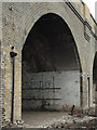
Railway arch by Raymouth Road (2)
In 2010 a number of railway arches alongside Raymouth Road that had previously been used by a commercial vehicle repair business were vacated, and renovated by Network Rail's contractors before being put up for rental again. See also Image
The foreman kindly allowed me far enough in to the site to take a couple of photos (I could not go further without the necessary permit, safety gear etc.)
There is an interesting drainage detail here as a pipe emerges at the springing level of the arch, presumably carrying drainage from the track ballast, and discharges into a hopper.
I don't know what the significance of the word "Tuesday" painted on the wall is!
Image: © Stephen Craven
Taken: 20 Jul 2010
0.02 miles
3
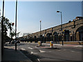
Raymouth Road arches restored (2)
One of three photos on completion of work by Network Rail to refurbish the arches under the London-Greenwich railway viaduct before re-letting them for commercial use. Formerly there were a number of businesses operating here, mainly vehicle maintenance. See Image for a 2007 view, and Image for renovation in progress.
This photo is taken from near the junction of Raymouth Road and Aspinden Road, with a zebra crossing in the foreground.
Image: © Stephen Craven
Taken: 2 Jun 2011
0.02 miles
4
Raymouth Road arches restored (4)
Some of the many businesses, mostly in the field of vehicle maintenance, occupying arches underneath the London Bridge to Greenwich railway viaduct. The ones along Raymouth Road were temporarily vacated, refurbished and re-let during 2010/11. See three similarly titled photos from 2011.
Image: © Stephen Craven
Taken: 2 May 2013
0.02 miles
5
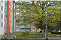
Nelldale Road
Looking away from the junction with Raymouth Road, with Maydew House Image in the background.
Image: © Stephen Craven
Taken: 2 May 2013
0.03 miles
6
Railway arch by Raymouth Road
In 2010 a number of railway arches alongside Raymouth Road that had previously been used by a commercial vehicle repair business were vacated, and renovated by Network Rail's contractors before being put up for rental again.
The foreman kindly allowed me far enough in to the site to take a couple of photos (I could not go further without the necessary permit, safety gear etc.)
The main viaduct at this point is 37m wide and carries nine tracks out of London Bridge, serving the North Kent, Lewisham/Hayes and Croydon/Brighton lines. As can be seen from this view it actually consists of at least two (probably three) separate structures side-by-side. A narrower viaduct (just visible behind) carries the two tracks of the line to Peckham Rye and Herne Hill.
Image: © Stephen Craven
Taken: 20 Jul 2010
0.03 miles
7
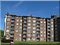
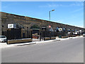
Bradley House
One of three wings of this star-shaped housing block on Raymouth Road.
Image: © Stephen Craven
Taken: 2 May 2013
0.04 miles
9
Raymouth Road arches restored (1)
One of three photos on completion of work by Network Rail to refurbish the arches under the London-Greenwich railway viaduct before re-letting them for commercial use. Formerly there were a number of businesses operating here, mainly vehicle maintenance. See Image for a 2007 view, and Image for renovation in progress.
Image: © Stephen Craven
Taken: 2 Jun 2011
0.04 miles
10
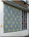
Detail of Abbeyfield Estate, Nelldale Road
A typical snippet of 1960s design on Bradley House.
Image: © Stephen Richards
Taken: 26 May 2013
0.04 miles