IMAGES TAKEN NEAR TO
Abbeyfield Road, LONDON, SE16 2BX
Introduction
This page details the photographs taken nearby to Abbeyfield Road, SE16 2BX by members of the Geograph project.
The Geograph project started in 2005 with the aim of publishing, organising and preserving representative images for every square kilometre of Great Britain, Ireland and the Isle of Man.

There are currently over 7.5m images from over14,400 individuals and you can help contribute to the project by visiting https://www.geograph.org.uk
Image Map
Images are licensed for reuse under creativecommons.org/licenses/by-sa/2.0
Notes
- Clicking on the map will re-center to the selected point.
- The higher the marker number, the further away the image location is from the centre of the postcode.
Image Listing (159 Images Found)
Images are licensed for reuse under creativecommons.org/licenses/by-sa/2.0
Image
Details
Distance
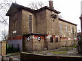
1
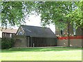
Dilston Grove annexe building
One of a pair of buildings currently known as Dilston Grove (after the name of a local street that no longer exists since post-war redevelopment). The site is now off Abbeyfield Road on the edge of Southwark Park.
This later building is an annexe to the former church Image and has been fitted with the same polycarbonate window protection as the church.
Image: © Stephen Craven
Taken: 22 May 2015
0.02 miles
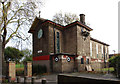
2

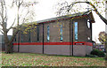
Dilston Grove (former church)
One of a pair of buildings currently known as Dilston Grove (after the name of a local street that no longer exists since post-war redevelopment). The site is now off Abbeyfield Road on the edge of Southwark Park.
This older building dates from 1912. It was originally known as the Clare College Mission (being founded by graduates of that Cambridge college) and later as the Church of the Epiphany. The architects were John Simpson & Maxwell Ayrton, and it is notable for being one of the earliest reinforced concrete (then known as ferro-concrete) churches in the UK. Now listed grade 2 (list entry number 1385919) mainly for that reason.
It was declared redundant as a church c.1950, and converted to artists' studios in the 1960's. Since 2010 it has been used as a single empty space for large scale art installations.
Image: © Stephen Craven
Taken: 22 May 2015
0.03 miles
3
Clare College Mission Church, Dilston Grove, Bermondsey
Also know as The Epiphany, Rotherhithe
Image: © John Salmon
Taken: 25 Nov 2013
0.04 miles
5
Clare College Mission Church, Dilston Grove, Bermondsey
Also known as The Epiphany, Rotherhithe
Image: © John Salmon
Taken: 25 Nov 2013
0.05 miles
6
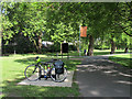
Southwark Park: cycle rack
These cycle stands are not particularly close to any of the park's main facilities, so the location is surprising, but proved convenient for photographing the nearby Dilston Grove buildings.
Image: © Stephen Craven
Taken: 22 May 2015
0.05 miles
7
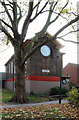
Clare College Mission
Situated in Dilston Grove, Rotherhithe and built in 1912 and a pioneer building being constructed of concrete on a bed of concrete. The "bed" was to prevent land slip as suffered by its predecessor. The designer was also responsible for the design of the original Wembley Stadium.
Image: © Chris Lordan
Taken: 30 Mar 2008
0.06 miles

9
Clare College Mission Church, Dilston Grove, Bermondsey
Also known as The Epiphany, Rotherhithe
Image: © John Salmon
Taken: 25 Nov 2013
0.06 miles
10
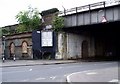
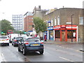
Entrance to Southwark Park British rail station
Situated in Rotherhithe New Road at the junction with Corbetts Passage. The entrance is beneath the bridge and two windows of the ticket office etc. in Corbetts Passage. Opened in 1902, closed as a war economy in 1915 and never re opened.
Image: © Chris Lordan
Taken: 7 Mar 2007
0.06 miles