IMAGES TAKEN NEAR TO
Millender Walk, LONDON, SE16 2BL
Introduction
This page details the photographs taken nearby to Millender Walk, SE16 2BL by members of the Geograph project.
The Geograph project started in 2005 with the aim of publishing, organising and preserving representative images for every square kilometre of Great Britain, Ireland and the Isle of Man.

There are currently over 7.5m images from over14,400 individuals and you can help contribute to the project by visiting https://www.geograph.org.uk
Image Map
Images are licensed for reuse under creativecommons.org/licenses/by-sa/2.0
Notes
- Clicking on the map will re-center to the selected point.
- The higher the marker number, the further away the image location is from the centre of the postcode.
Image Listing (161 Images Found)
Images are licensed for reuse under creativecommons.org/licenses/by-sa/2.0
Image
Details
Distance
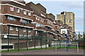
2

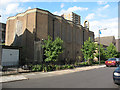
Silwood Estate, Rotherhithe, London, SE16
It used to cover a very large area bounded by Rotherhithe New Road, Silwood Street, Reculver Road and Oldfield Grove. Part was in Rotherhithe and a small section in Lewisham. Image shows the now derelict Gillam House in Silwood Street named after Samuel Gillam (JP) who, in April 1764, sentenced the murderer William Corbett to death. Behind the flats is Corbetts Lane and to the left of the photographer is Corbetts Passage. The London Nautical School in Lambeth started in a school in Silwood Street, the Rotherhithe side of (site of the recently demolished Goldsworthy Gardens) Reculver Road. School evacuated to Sussex during WWII and on its return moved to Lambeth. Incidentally General Goldsworthy was Lord of the Manor of Rotherhithe from 1777 to 1801.
Image: © Chris Lordan
Taken: 12 Oct 2009
0.04 miles
3
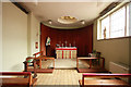
St Katharine with St Bartholomew, Eugenia Road - Lady chapel
Image: © John Salmon
Taken: 17 Feb 2011
0.04 miles
4
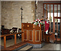
St Katharine with St Bartholomew, Eugenia Road - Ambo
Image: © John Salmon
Taken: 17 Feb 2011
0.04 miles
5
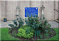
St Katharine with St Bartholomew, Eugenia Road - Notice board
Image: © John Salmon
Taken: 17 Feb 2011
0.04 miles
6
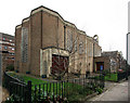
St Katharine with St Bartholomew, Eugenia Road
Image: © John Salmon
Taken: 17 Feb 2011
0.05 miles
7
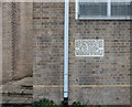
St Katharine with St Bartholomew, Eugenia Road - Foundation stone
Image: © John Salmon
Taken: 17 Feb 2011
0.05 miles
8
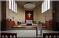
St Katharine with St Bartholomew, Eugenia Road - Chancel
Image: © John Salmon
Taken: 17 Feb 2011
0.05 miles
9
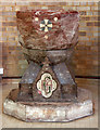
St Katharine with St Bartholomew, Eugenia Road - Font
Image: © John Salmon
Taken: 17 Feb 2011
0.05 miles
10
St Katharine's church, South Bermondsey
This Anglican parish church was built in 1960 to the designs of Covell, Matthews and Partners, on the site of an earlier 19th century church that had been badly damaged by wartime bombing. It is notable for its copper roof and 'zig-zag' walls.
Image: © Stephen Craven
Taken: 20 Aug 2009
0.05 miles