IMAGES TAKEN NEAR TO
Silwood Street, LONDON, SE16 2BF
Introduction
This page details the photographs taken nearby to Silwood Street, SE16 2BF by members of the Geograph project.
The Geograph project started in 2005 with the aim of publishing, organising and preserving representative images for every square kilometre of Great Britain, Ireland and the Isle of Man.

There are currently over 7.5m images from over14,400 individuals and you can help contribute to the project by visiting https://www.geograph.org.uk
Image Map (Loading...)


Getting Data...Please wait
Leaflet Map data © OpenStreetMap
Images are licensed for reuse under creativecommons.org/licenses/by-sa/2.0
Notes
- Clicking on the map will re-center to the selected point.
- The higher the marker number, the further away the image location is from the centre of the postcode.
Image Listing (182 Images Found)
Images are licensed for reuse under creativecommons.org/licenses/by-sa/2.0
Image
Details
Distance
1
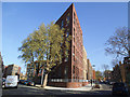
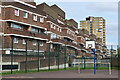
New apartments on Silwood Street
An apartment block, on the acute corner of Silwood Street (ahead) and Corbetts Lane (left), in the redevelopment of the Silwood estate - see Image for the block that formerly stood here.
Image: © Stephen Craven
Taken: 16 Apr 2014
0.01 miles
2

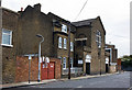
Silwood Estate, Rotherhithe, London, SE16
It used to cover a very large area bounded by Rotherhithe New Road, Silwood Street, Reculver Road and Oldfield Grove. Part was in Rotherhithe and a small section in Lewisham. Image shows the now derelict Gillam House in Silwood Street named after Samuel Gillam (JP) who, in April 1764, sentenced the murderer William Corbett to death. Behind the flats is Corbetts Lane and to the left of the photographer is Corbetts Passage. The London Nautical School in Lambeth started in a school in Silwood Street, the Rotherhithe side of (site of the recently demolished Goldsworthy Gardens) Reculver Road. School evacuated to Sussex during WWII and on its return moved to Lambeth. Incidentally General Goldsworthy was Lord of the Manor of Rotherhithe from 1777 to 1801.
Image: © Chris Lordan
Taken: 12 Oct 2009
0.03 miles
3
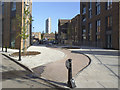
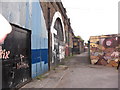
Cycle path to Debnams Street
A sinuous brick-paved path links Corbetts Lane with Debnams Street.
Image: © Stephen Craven
Taken: 16 Apr 2014
0.04 miles
5
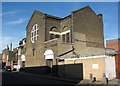
St. Gertrude
An unusual church located on Debnams Road. The housing accommodation attached is presumably the vicarage. The church was built in 1902 and was designed by F.W.Tasker.
Image: © Martin Addison
Taken: 22 Oct 2010
0.06 miles
6
St Gertrude's Church, 1, Debnams Road, Rotherhithe, London, SE16
A Roman Catholic church built in 1902 and said to have been built to cater for the vast number of Irish labourers who came to the area to assist in the building of the railway on the nearby viaduct. That said, the viaduct was built or started about 1832ish.
Image: © Chris Lordan
Taken: 27 Oct 2009
0.06 miles
7
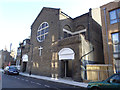
St Gertrude's Catholic church, Debnams Street
According to another contributor Image, the church was built in 1902 and the style is certainly of that era.
Image: © Stephen Craven
Taken: 16 Apr 2014
0.06 miles
9
Corbetts Passage, Rotherhithe, London, SE16
Off Rotherhithe New Road, opposite Raymouth Road and runs into Silwood Street. Many will know it's named after the Canadian murderer, William Corbett, who was hanged on 04-04-1764 for two murders in Cherry Garden Street, Bermondsey, SE1. His body was hung on a gibbet in Rotherhithe New Road (then Deptford Road). What may not be known is on the railway lines above, about 1839 the worlds first signal box was erected. Far end of the image can be seen Southwark Park British Rail Station (1902 to 1915).
Image: © Chris Lordan
Taken: 23 Sep 2009
0.07 miles
10

Bolina Road bridges (1)
Bolina Road is a narrow minor road, used mainly by commercial vehicles going to/from local industrial sites, that passes under five railway bridges, three of them shown on this picture. The lowest of them, in the distance on this photo, is disused (it carried the former Bricklayers Arms freight line). The others all lead towards London Bridge.
Update: Bolina Road was to be closed permanently from 18 January 2013 for construction of new railway lines as part of the Thameslink project.
Image: © Stephen Craven
Taken: 22 Oct 2008
0.07 miles