IMAGES TAKEN NEAR TO
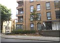
New Tannery Way, LONDON, SE1 5ZW
Introduction
This page details the photographs taken nearby to New Tannery Way, SE1 5ZW by members of the Geograph project.
The Geograph project started in 2005 with the aim of publishing, organising and preserving representative images for every square kilometre of Great Britain, Ireland and the Isle of Man.

There are currently over 7.5m images from over14,400 individuals and you can help contribute to the project by visiting https://www.geograph.org.uk
Image Map
Images are licensed for reuse under creativecommons.org/licenses/by-sa/2.0
Notes
- Clicking on the map will re-center to the selected point.
- The higher the marker number, the further away the image location is from the centre of the postcode.
Image Listing (182 Images Found)
Images are licensed for reuse under creativecommons.org/licenses/by-sa/2.0
Image
Details
Distance
1
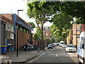
Crimscott Street
A road lined with small industrial and business units, off Grange Road, Bermondsey. It is one-way southbound towards Willow Walk, hence the arrow painted on the road.
Image: © Stephen Craven
Taken: 2 Jun 2011
0.02 miles
2
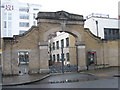
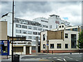
The Alaska Factory Gate, Bermondsey, SE1
The factory was opened in 1869 for the processing of the Alaskan furseal. The wall is all that remains of the original construction. The white building behind was erected I believe in the 1950s.
Image: © John Goodall
Taken: 11 Jan 2006
0.04 miles
3
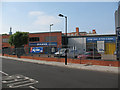
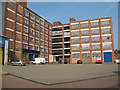
Access Storage, Willow Walk
A commercial growth area in recent years has been "self storage" facilities for people living in small city apartments. As of 2014 this building and others around it were scheduled to be replaced by yet another housing development, as Bermondsey gradually loses its industrial past.
Image: © Stephen Craven
Taken: 2 Jun 2011
0.05 miles
4
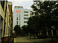
Former Alaska factory, Bermondsey
See also Image The Alaska Factory opened in 1869 for the processing of Alaskan fur seals. The boundary wall is all that remains of the original construction. The main "art deco" building by Wallis and Gilbert, seen here with illuminated sign, dates from the 1930s. It is now converted to housing.
Image: © Stephen Craven
Taken: 7 Oct 2013
0.06 miles
5
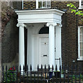
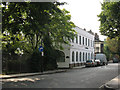
Detail of 44 Grange Road
Ionic porch on a house dated c1800.
Image: © Stephen Richards
Taken: 27 May 2013
0.06 miles
6
Crisis Warehouse, Willow Walk
The warehouse facility of a charity for homeless people. As of 2014 this building and others around it were scheduled to be replaced by yet another housing development, as Bermondsey gradually loses its industrial past.
Image: © Stephen Craven
Taken: 2 Jun 2011
0.06 miles
7
'Alaska' building
A former fur processing factory, now flats.
Image: © Robin Webster
Taken: 23 Jul 2011
0.06 miles
8
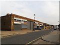
Next for the chop?
Most of these light industrial units on the east side of Pages Walk, part of the "Rich Industrial Estate", were already closed and "for sale" by summer 2013. I expect that they would be demolished and replaced by houses as has already happened across the road Image, as Bermondsey becomes ever more “gentrified”.
Image: © Stephen Craven
Taken: 16 Jul 2013
0.06 miles
10
Willow Walk
Willow Walk runs along the north side of the former Bricklayers Arms railway goods yard. The white building on the corner, now called The Willows, was probably railway offices originally but now hosts several small business.
Image: © Stephen Craven
Taken: 2 Jun 2011
0.07 miles