IMAGES TAKEN NEAR TO
Coopers Road, LONDON, SE1 5YA
Introduction
This page details the photographs taken nearby to Coopers Road, SE1 5YA by members of the Geograph project.
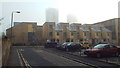
The Geograph project started in 2005 with the aim of publishing, organising and preserving representative images for every square kilometre of Great Britain, Ireland and the Isle of Man.

There are currently over 7.5m images from over14,400 individuals and you can help contribute to the project by visiting https://www.geograph.org.uk
Image Map
Images are licensed for reuse under creativecommons.org/licenses/by-sa/2.0
Notes
- Clicking on the map will re-center to the selected point.
- The higher the marker number, the further away the image location is from the centre of the postcode.
Image Listing (149 Images Found)
Images are licensed for reuse under creativecommons.org/licenses/by-sa/2.0
Image
Details
Distance
2
Rolls Road, Bermondsey
Looking east from opposite Avocet Close.
Image: © Stephen Craven
Taken: 24 Apr 2010
0.08 miles
3
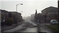
Oxley Close, SE1
Oxley Close in inner South East London. Housing was developed here in the 1980s, on a site previously occupied by a railway goods yard.
This image was taken on a day in April 2014 when London's air quality was particularly poor.
Image: © Malc McDonald
Taken: 1 Apr 2014
0.08 miles
4
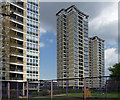
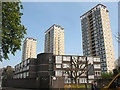
Avondale Square Estate, Old Kent Road
Three soaring twenty-storey towers, imaginatively named West Point, Centre Point and East Point. They were built in 1961-63 and look pretty well preserved.
Image: © Stephen Richards
Taken: 6 May 2013
0.09 miles
5
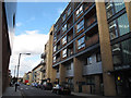
Coopers Road
New housing just off the Old Kent Road. For Success House in the foreground see Image
Image: © Stephen Craven
Taken: 22 Jul 2015
0.09 miles
6
West, Centre, East Points
Whoever came up with the names for these three tower blocks on Longland Court, Bermondsey (West Point, Centre Point, East Point) obviously had little imagination! Viewed from Rolls Road.
Image: © Stephen Craven
Taken: 24 Apr 2010
0.09 miles
7
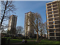
Avondale Square: tower blocks
Two of the three high-rise blocks on the Avondale Square estate are seen here: West Point and Centre Point. East Point can just be glimpsed behind the building in the foreground.
Image: © Stephen Craven
Taken: 14 Apr 2015
0.09 miles
8
Quietway improvements (2)
Where Oxley Close meets Abercorn Way, the former narrow gap Image was replaced around April 2015 with a wider gap to allow cyclists through at higher speeds, and more signage to indicate that it is part of the London Cycle Network (and the new "quietway" from Waterloo to Greenwich).
Image: © Stephen Craven
Taken: 10 Jul 2015
0.10 miles
9
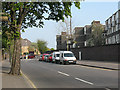
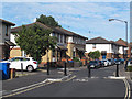
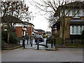
Mawbey Road, SE1
Mawbey Road, just off Old Kent Road in inner south east London.
This image was taken on a morning when air quality was particularly poor. What looks like mist was in fact pollution.
Image: © Malc McDonald
Taken: 1 Apr 2014
0.10 miles
10
Chaucer Drive meets Oxley Close
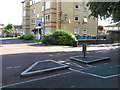
What appears on the map to be the spine road of this housing estate is in fact broken up into several short sections, each separately named with its own independent access from Rolls Road. This is the eastern end of Chaucer Drive where it joins Oxley Close. The barriers are 'permeable' to allow cyclists and pedestrians along the full length of the road, part of the London Cycle Network. For the next such point along the road, see Image
The estate is on the site of the former Bricklayers Arms railway goods yard.
Image: © Stephen Craven
Taken: 25 Jan 2014
0.11 miles