IMAGES TAKEN NEAR TO
Longfield Estate, LONDON, SE1 5TL
Introduction
This page details the photographs taken nearby to Longfield Estate, SE1 5TL by members of the Geograph project.
The Geograph project started in 2005 with the aim of publishing, organising and preserving representative images for every square kilometre of Great Britain, Ireland and the Isle of Man.

There are currently over 7.5m images from over14,400 individuals and you can help contribute to the project by visiting https://www.geograph.org.uk
Image Map
Images are licensed for reuse under creativecommons.org/licenses/by-sa/2.0
Notes
- Clicking on the map will re-center to the selected point.
- The higher the marker number, the further away the image location is from the centre of the postcode.
Image Listing (88 Images Found)
Images are licensed for reuse under creativecommons.org/licenses/by-sa/2.0
Image
Details
Distance
1
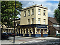
The Claremont
This pub appeared to be open - becoming a London rarity - but zooming in on the notices in the windows it appears it is temporarily closed! Let's hope it is only a short closure.
Image: © Robin Webster
Taken: 23 Jul 2011
0.04 miles
2
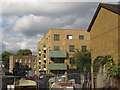
New flats off Willow Walk, Bermondsey
A matching building to nearby Ros Stark House Image
Image: © Stephen Craven
Taken: 22 Jul 2015
0.06 miles
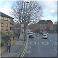
3

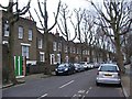
Southwark Park Road
A sweeping curve on the road as it passes the Longfield Estate - the low-rise blocks of which are on the left of the photo.
Image: © Martin Addison
Taken: 22 Oct 2010
0.07 miles
4
Dunton Road, junction with Southwark Park Road
Image: © Robert Eva
Taken: 12 Jan 2020
0.07 miles
5
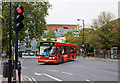
Turning Onto Dunton Road
A 78 bus sneaks through as the lights change on route to Nunhead from Shoreditch. The vehicle is a Dennis Dart with Alexander ALX200 bodywork. This combination is relatively rare in London with the equivalent Plaxton Pointer being a much more common choice.
Image: © Martin Addison
Taken: 22 Oct 2010
0.07 miles
6
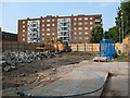
Demolition site on Lynton Road
The site is opposite Otterden Terrace Image It was not clear at this stage what was to be built here, and I cannot remember what building was here before. For a later view after construction, see Image
Image: © Stephen Craven
Taken: 2 Jun 2011
0.08 miles
7
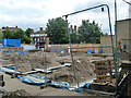
Building site, Lynton Road
This turned out to be for housing.
Image: © Robin Webster
Taken: 23 Jul 2011
0.08 miles
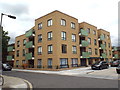
9
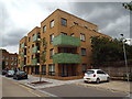
New council housing in Bermondsey
Since the 1980s, the number of council homes has dwindled as homes have been sold off, while few new council homes have been built.
Southwark Council, in inner South East London, is embarking on an ambitious programme to build thousands of new council homes over the years ahead.
This block in Bermondsey is one of the first to have been completed with tenants moving in at the end of 2015.
Image: © Malc McDonald
Taken: 4 Sep 2016
0.08 miles
10
New council homes in Bermondsey
Since the 1980s, the number of council homes has dwindled as homes have been sold off, while few new council homes have been built.
Southwark Council, in inner South East London, is embarking on an ambitious programme to build thousands of new council homes over the years ahead.
This block in Bermondsey is one of the first to have been completed with tenants moving in at the end of 2015.
Image: © Malc McDonald
Taken: 4 Sep 2016
0.08 miles