IMAGES TAKEN NEAR TO
Monnow Road, LONDON, SE1 5RP
Introduction
This page details the photographs taken nearby to Monnow Road, SE1 5RP by members of the Geograph project.
The Geograph project started in 2005 with the aim of publishing, organising and preserving representative images for every square kilometre of Great Britain, Ireland and the Isle of Man.

There are currently over 7.5m images from over14,400 individuals and you can help contribute to the project by visiting https://www.geograph.org.uk
Image Map
Images are licensed for reuse under creativecommons.org/licenses/by-sa/2.0
Notes
- Clicking on the map will re-center to the selected point.
- The higher the marker number, the further away the image location is from the centre of the postcode.
Image Listing (91 Images Found)
Images are licensed for reuse under creativecommons.org/licenses/by-sa/2.0
Image
Details
Distance
1
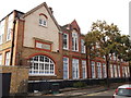
Spa School, Bermondsey
On Monnow Road.
See http://en.wikipedia.org/wiki/Spa_School for more details on the School for children with autism.
Image: © David Anstiss
Taken: 25 Sep 2011
0.04 miles
2
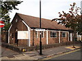
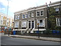
Monnow Road Baptist School, Bermondsey
On the junction of Monnow Road (on the left) and Trothy Road (on the right).
Image: © David Anstiss
Taken: 25 Sep 2011
0.06 miles
3
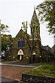
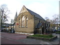
St. Annes
Located in Thorburn Square. Designed by J.Porter, it was built between 1869 and 1872.
Image: © Martin Addison
Taken: 22 Oct 2010
0.06 miles
4
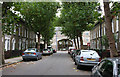
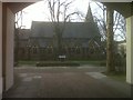
Longley Road
A tree-lined street connecting Southwark Park Road with Thorburn Square. The houses of the square are of modern construction whilst those on Longley Road look to be Georgian. Through the arch, leading into the square, the parish church of St. Annes can be seen.
Image: © Martin Addison
Taken: 22 Oct 2010
0.07 miles
5
Church in the square
St Anne's Church is surrounded on all four sides by Thorburn Square making it tricky to get the whole building in.
Image: © Ian Paterson
Taken: 8 Feb 2010
0.07 miles
7
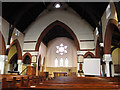
Interior of St Anne's church, Bermondsey
The church has a pleasing simplicity to its architecture. Originally a simple nave-and-chancel arrangement, the side aisles were added in the later 19th century. It retains its pews. See Image for an external view.
Image: © Stephen Craven
Taken: 16 Aug 2012
0.07 miles
8
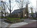
St Anne's Church, Thorburn Square
St Anne's Church was built at the end of the 1860s. The parish has now been combined with that of St Augustine's in Lynton Road which was sold in 2005 for residential use. Thorburn Square itself has been pedestrianised and so this photograph is happily car-free.
Image: © Marathon
Taken: 16 Nov 2011
0.07 miles
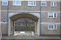
10
St James' CE Pre-School, Thorburn Square
If this was a complete school, it must have been one of the smallest in London, more akin to a village school. It is now St James' CE Pre-School, although the church behind, the spire of which can just be seen, is actually St Anne & St Augustine - see http://www.geograph.org.uk/photo/2696872 The church of St James is a little way away in Thurland Road - see http://www.geograph.org.uk/photo/2647632 Thorburn Square itself has been pedestrianised and so this photograph is happily car-free.
Image: © Marathon
Taken: 16 Nov 2011
0.08 miles