IMAGES TAKEN NEAR TO
Lynton Estate, Lynton Road, LONDON, SE1 5QU
Introduction
This page details the photographs taken nearby to Lynton Estate, Lynton Road, SE1 5QU by members of the Geograph project.
The Geograph project started in 2005 with the aim of publishing, organising and preserving representative images for every square kilometre of Great Britain, Ireland and the Isle of Man.

There are currently over 7.5m images from over14,400 individuals and you can help contribute to the project by visiting https://www.geograph.org.uk
Image Map
Images are licensed for reuse under creativecommons.org/licenses/by-sa/2.0
Notes
- Clicking on the map will re-center to the selected point.
- The higher the marker number, the further away the image location is from the centre of the postcode.
Image Listing (100 Images Found)
Images are licensed for reuse under creativecommons.org/licenses/by-sa/2.0
Image
Details
Distance
1
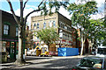
Former Carpenters Arms, Lynton Street
A former Trumans pub, here being converted into flats. It has an impressive display of small statues - lightly clad young ladies - at first floor level, which fortunately have survived the conversion. What had they to do with carpenters?
Image: © Robin Webster
Taken: 23 Jul 2011
0.02 miles
2
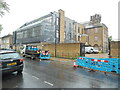
Bermondsey Telephone Exchange (1)
Situated in Lynton Road SE1 5QX, this TE has the code CLBER. It provides telephone and broadband services to approximately 28,938 residential and 1,138 non-residential premises in the Bermondsey area. The former building is to the right whilst the extension is on the left.
Image: © David Hillas
Taken: 20 May 2022
0.06 miles
3
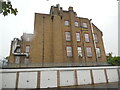
Bermondsey Telephone Exchange (2)
Situated in Lynton Road, this TE used to have BERmondsey numbers until the late 1960s, but now has 0207-231, 232, 237 and 394 xxxx plus some other Inner London numbers. Mobile phone aerials can be seen on the roof of the old building, while BT and Openreach vehicles are parked in front of it.
Image: © David Hillas
Taken: 20 May 2022
0.06 miles
4
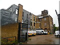
Rear of Bermondsey Telephone Exchange
This photo shows the back of the TE from the driveway off Monnow Road. Ventilation louvres can be seen on some of its windows, while garages belonging to residents of the Thorburn Square flats are located in front of the TE.
Image: © David Hillas
Taken: 20 May 2022
0.06 miles
5
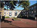
Thorburn Square, Bermondsey
The square has flats round all four sides; in the centre (visible at the left of the photos) is the church Image
Image: © Stephen Craven
Taken: 19 Aug 2009
0.07 miles
6
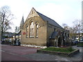
St James' CE Pre-School, Thorburn Square
If this was a complete school, it must have been one of the smallest in London, more akin to a village school. It is now St James' CE Pre-School, although the church behind, the spire of which can just be seen, is actually St Anne & St Augustine - see http://www.geograph.org.uk/photo/2696872 The church of St James is a little way away in Thurland Road - see http://www.geograph.org.uk/photo/2647632 Thorburn Square itself has been pedestrianised and so this photograph is happily car-free.
Image: © Marathon
Taken: 16 Nov 2011
0.07 miles
7
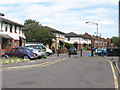
Oxley Close / Abercorn Way
What appears on the map to be the spine road of this housing estate is in fact broken up into several short sections, each separately named with its own independent access from Rolls Road. This is the eastern end of Oxley Close where it joins Abercorn Way. The barriers are 'permeable' to allow cyclists and pedestrians along the full length of the road, part of the London Cycle Network.
The estate is on the site of the former Bricklayers Arms railway goods yard.
Image: © Stephen Craven
Taken: 18 Jul 2009
0.07 miles
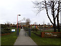
8
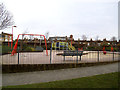
Playground in Paterson Park
Play equipment for young children.
Image: © Stephen Craven
Taken: 25 Jan 2014
0.07 miles
9
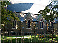
St Anne's church, Bermondsey - south side
It is difficult to photograph this church because of trees all round it. For another view see Image It was built in 1872.
Image: © Stephen Craven
Taken: 19 Aug 2009
0.08 miles
10
Entrance to Paterson Park
A small urban park off Abercorn Way.
Image: © Stephen Craven
Taken: 25 Jan 2014
0.08 miles