IMAGES TAKEN NEAR TO
Balaclava Road, LONDON, SE1 5PR
Introduction
This page details the photographs taken nearby to Balaclava Road, SE1 5PR by members of the Geograph project.
The Geograph project started in 2005 with the aim of publishing, organising and preserving representative images for every square kilometre of Great Britain, Ireland and the Isle of Man.

There are currently over 7.5m images from over14,400 individuals and you can help contribute to the project by visiting https://www.geograph.org.uk
Image Map (Loading...)


Getting Data...Please wait
Leaflet Map data © OpenStreetMap
Images are licensed for reuse under creativecommons.org/licenses/by-sa/2.0
Notes
- Clicking on the map will re-center to the selected point.
- The higher the marker number, the further away the image location is from the centre of the postcode.
Image Listing (81 Images Found)
Images are licensed for reuse under creativecommons.org/licenses/by-sa/2.0
Image
Details
Distance
1
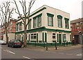
Havelock House, Bermondsey
Formerly the Havelock Arms, and now flats. On the corner of Fort Road and Balaclava Road.
Image: © Derek Harper
Taken: 9 Feb 2011
0.03 miles
2
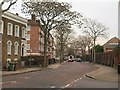
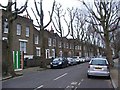
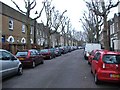
Lynton Road, Bermondsey
At the junction with Chaucer Drive, as the sign shows. The brick flats on the left are part of Stansfield House on the Longfield estate.
Image: © Derek Harper
Taken: 9 Feb 2011
0.07 miles
3
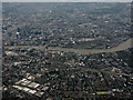
Bermondsey from the air
With the Thames and the City of London beyond. Viewed from a Heathrow bound flight from Glasgow.
Image: © Thomas Nugent
Taken: 10 Aug 2016
0.09 miles
4
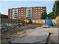
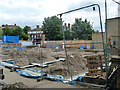
Demolition site on Lynton Road
The site is opposite Otterden Terrace Image It was not clear at this stage what was to be built here, and I cannot remember what building was here before. For a later view after construction, see Image
Image: © Stephen Craven
Taken: 2 Jun 2011
0.09 miles
5
Building site, Lynton Road
This turned out to be for housing.
Image: © Robin Webster
Taken: 23 Jul 2011
0.09 miles
6
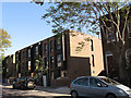
New apartments on Lynton Road
This block was constructed and occupied less than a year after the previous view before construction Image
Image: © Stephen Craven
Taken: 25 May 2012
0.10 miles
8
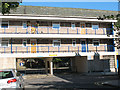
Entrance to Thorburn Square
The square has post-war flats round all its four sides, with a ground-level entrance like this in the middle of each side. This is the entrance from Reverdy Road on the west side of the square.
Image: © Stephen Craven
Taken: 19 Aug 2009
0.10 miles
10
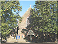
St Anne's church, Bermondsey - west end
The church is a well-kept secret, in a secluded square Image - a 19th century survival surrounded by post-war flats.
Image: © Stephen Craven
Taken: 19 Aug 2009
0.12 miles