IMAGES TAKEN NEAR TO
St. James's Road, LONDON, SE1 5LN
Introduction
This page details the photographs taken nearby to St. James's Road, SE1 5LN by members of the Geograph project.
The Geograph project started in 2005 with the aim of publishing, organising and preserving representative images for every square kilometre of Great Britain, Ireland and the Isle of Man.

There are currently over 7.5m images from over14,400 individuals and you can help contribute to the project by visiting https://www.geograph.org.uk
Image Map
Images are licensed for reuse under creativecommons.org/licenses/by-sa/2.0
Notes
- Clicking on the map will re-center to the selected point.
- The higher the marker number, the further away the image location is from the centre of the postcode.
Image Listing (93 Images Found)
Images are licensed for reuse under creativecommons.org/licenses/by-sa/2.0
Image
Details
Distance
1
St James' Road, Bermondsey
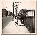
Taken in 1951 this photo, looking north along St James' Road (towards Southwark Park Road in the far distance), shows the prefabs on the east side of St James' Road between Fort Road and Strathnairn Street. The corner shop behind the lady's shoulder used to be a bagwash and is on the corner of Strathnairn Street and St James' Road. The prefabs have long since gone and Townsend House now stands on the site.
Image: © Ken Ripper
Taken: 1 Apr 1951
0.02 miles
2
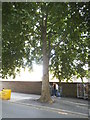
Tree on Southwark Park Road, Bermondsey
Image: © David Howard
Taken: 6 Aug 2017
0.09 miles
3
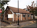
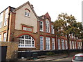
Monnow Road Baptist School, Bermondsey
On the junction of Monnow Road (on the left) and Trothy Road (on the right).
Image: © David Anstiss
Taken: 25 Sep 2011
0.10 miles
4
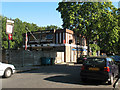
St George's Tavern, Camilla Road, Bermondsey
Image: © Stephen Craven
Taken: 19 Aug 2009
0.10 miles
5
Spa School, Bermondsey
On Monnow Road.
See http://en.wikipedia.org/wiki/Spa_School for more details on the School for children with autism.
Image: © David Anstiss
Taken: 25 Sep 2011
0.10 miles
6
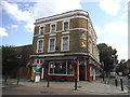
The Queen Victoria on Southwark Park Road
Image: © David Howard
Taken: 6 Aug 2017
0.11 miles
7
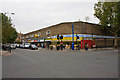
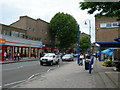
St. James Supermarket
The junction between Southwark Park Road and St. James's Road, a featureless expanse of tarmac and a non-descript brick building.
Image: © Martin Addison
Taken: 22 Oct 2010
0.11 miles
8
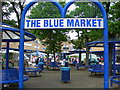
The Blue Market
A market off "The Blue", Southwark Park Road.
Image: © Danny P Robinson
Taken: 15 Jun 2007
0.11 miles
9
Southwark Park Road, SE16 (1)
This is a shopping area known locally as "The Blue".
Image: © Danny P Robinson
Taken: 15 Jun 2007
0.11 miles
10
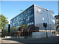
City of London Academy
The Academy is not actually in the City of London - the name reflects the Corporation of London's input as sponsors. It is a state secondary school situated on the junction of Lynton Road and St James Road, Bermondsey, and the present buildings opened in 2005. Their website is http://www.cityacademy.co.uk/
Image: © Stephen Craven
Taken: 19 Aug 2009
0.11 miles