IMAGES TAKEN NEAR TO
Acanthus Drive, LONDON, SE1 5HH
Introduction
This page details the photographs taken nearby to Acanthus Drive, SE1 5HH by members of the Geograph project.
The Geograph project started in 2005 with the aim of publishing, organising and preserving representative images for every square kilometre of Great Britain, Ireland and the Isle of Man.

There are currently over 7.5m images from over14,400 individuals and you can help contribute to the project by visiting https://www.geograph.org.uk
Image Map
Images are licensed for reuse under creativecommons.org/licenses/by-sa/2.0
Notes
- Clicking on the map will re-center to the selected point.
- The higher the marker number, the further away the image location is from the centre of the postcode.
Image Listing (109 Images Found)
Images are licensed for reuse under creativecommons.org/licenses/by-sa/2.0
Image
Details
Distance
1
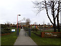
Entrance to Paterson Park
A small urban park off Abercorn Way.
Image: © Stephen Craven
Taken: 25 Jan 2014
0.05 miles
2
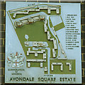
Avondale Square: estate map
This relief map showing the names of all the housing blocks on the estate appears to be contemporary with the buildings i.e. c.1962
Image: © Stephen Craven
Taken: 14 Apr 2015
0.06 miles
3
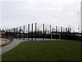
Football cage in Paterson Park
The caged hard play area is provided with goals for 5-a-side football, and basketball hoops.
Image: © Stephen Craven
Taken: 25 Jan 2014
0.06 miles
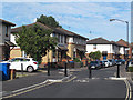
4
Zebra crossing on Marlborough Grove, South Bermondsey
The crossing links the Avondale Square estate with the Phoenix primary school Image
Image: © Stephen Craven
Taken: 14 Apr 2015
0.06 miles
5
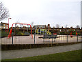
Playground in Paterson Park
Play equipment for young children.
Image: © Stephen Craven
Taken: 25 Jan 2014
0.06 miles
6
Quietway improvements (2)
Where Oxley Close meets Abercorn Way, the former narrow gap Image was replaced around April 2015 with a wider gap to allow cyclists through at higher speeds, and more signage to indicate that it is part of the London Cycle Network (and the new "quietway" from Waterloo to Greenwich).
Image: © Stephen Craven
Taken: 10 Jul 2015
0.06 miles
7
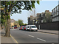
Rolls Road, Bermondsey
Looking east from opposite Avocet Close.
Image: © Stephen Craven
Taken: 24 Apr 2010
0.06 miles
8
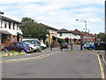
Oxley Close / Abercorn Way
What appears on the map to be the spine road of this housing estate is in fact broken up into several short sections, each separately named with its own independent access from Rolls Road. This is the eastern end of Oxley Close where it joins Abercorn Way. The barriers are 'permeable' to allow cyclists and pedestrians along the full length of the road, part of the London Cycle Network.
The estate is on the site of the former Bricklayers Arms railway goods yard.
Image: © Stephen Craven
Taken: 18 Jul 2009
0.07 miles
9
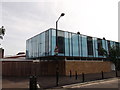
The Phoenix School, Marlborough Grove, South Bermondsey
This primary school with its distinctive pink and blue cladding (is that intended to imply separation of girls and boys?) was originally called the Eveline Lowe School. It serves the adjacent Avondale Square estate opened in 1962. The school opened in 1967, designed by David and Mary Medd for the Department of Education and Science in partnership with the Inner London Education Authority.
The school was listed grade 2 in 2006 (list entry number 1391693) because it "marks an important phase in post-war educational ideas and design, for which it has special historic interest." See also Image
Image: © Stephen Craven
Taken: 14 Apr 2015
0.07 miles
10
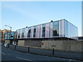
Eveline Lowe School, Bermondsey
A Grade II listed School on the junction of Rolls Road and Marlborough Grove. Built in 1966. Not very historic but classic 60's design of glass panels within a steel frame.
See http://www.britishlistedbuildings.co.uk/en-494384-eveline-lowe-school-bermondsey for much, much more about the building and the ethos of the school and design!
Image: © David Anstiss
Taken: 25 Sep 2011
0.07 miles