IMAGES TAKEN NEAR TO
Old Kent Road, LONDON, SE1 5EW
Introduction
This page details the photographs taken nearby to Old Kent Road, SE1 5EW by members of the Geograph project.
The Geograph project started in 2005 with the aim of publishing, organising and preserving representative images for every square kilometre of Great Britain, Ireland and the Isle of Man.

There are currently over 7.5m images from over14,400 individuals and you can help contribute to the project by visiting https://www.geograph.org.uk
Image Map
Images are licensed for reuse under creativecommons.org/licenses/by-sa/2.0
Notes
- Clicking on the map will re-center to the selected point.
- The higher the marker number, the further away the image location is from the centre of the postcode.
Image Listing (109 Images Found)
Images are licensed for reuse under creativecommons.org/licenses/by-sa/2.0
Image
Details
Distance
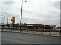
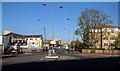
3
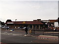
McDonald's Restaurant, Camberwell
On the junction of A2 Old Kent Road (in front) and Olmar Street (on the left).
Image: © David Anstiss
Taken: 25 Sep 2011
0.05 miles
7
Site of the Royal George public house
The Royal George public house was at 449 Rotherhithe New Road, SE16 junction with Verney Road although I do not know which side - so have shown both. Details obtained from an 1894 map and I cannot add any more dates. Gates in the background lead to a trading estate that was built on the filled in Grand Surrey Canal.
Image: © Chris Lordan
Taken: 10 Apr 2011
0.07 miles
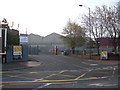
9
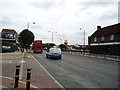
St James's Road, SE17
Looking north. The area on the left is the Six Bridges trading estate.
Image: © Philip Talmage
Taken: 18 Nov 2005
0.07 miles
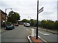
10
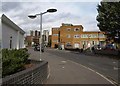
Malt Street, SE1
On the left is the east side of Image The block on the right includes a church and a heating firm. Ahead, in Image, is the junction with the Old Kent Road.
Image: © Derek Harper
Taken: 17 Oct 2011
0.08 miles