IMAGES TAKEN NEAR TO
Oakley Place, LONDON, SE1 5AD
Introduction
This page details the photographs taken nearby to Oakley Place, SE1 5AD by members of the Geograph project.
The Geograph project started in 2005 with the aim of publishing, organising and preserving representative images for every square kilometre of Great Britain, Ireland and the Isle of Man.

There are currently over 7.5m images from over14,400 individuals and you can help contribute to the project by visiting https://www.geograph.org.uk
Image Map
Images are licensed for reuse under creativecommons.org/licenses/by-sa/2.0
Notes
- Clicking on the map will re-center to the selected point.
- The higher the marker number, the further away the image location is from the centre of the postcode.
Image Listing (159 Images Found)
Images are licensed for reuse under creativecommons.org/licenses/by-sa/2.0
Image
Details
Distance
1
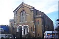
Thursday Prayerist Church - Seen from Oakley Place
Part of The Eternal Sacred Order of Cherubim and Seraphim Church, Walworth.
See Image for more details.
Image: © David Anstiss
Taken: 27 Nov 2009
0.03 miles
2
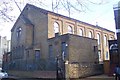
Thursday Prayerist Church
On Cobourg Road. Part of The Eternal Sacred Order of Cherubim and Seraphim Church - Nigerian Institutional Church. See Image
Image: © David Anstiss
Taken: 27 Nov 2009
0.04 miles
3

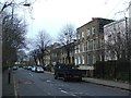
Cobourg Road
There are some impressive houses along Cobourg Road, many dating from late Georgian times. On the right is Burgess Park which at the time of this photograph was closed off here as part of a £6 million rejuvenation scheme.
Image: © Marathon
Taken: 16 Nov 2011
0.04 miles
4
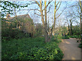
Cobourg Road nature reserve, Peckham
A plaque on the railings explains that this small area was deliberately left to revert to nature when Burgess Park across the road was developed. See also Image
Image: © Stephen Craven
Taken: 14 Apr 2015
0.04 miles
6
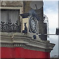
Lord Nelson clock
It has not been working for years.
Image: © Robert Eva
Taken: 1 Jan 2018
0.05 miles
7
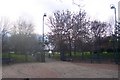
Burgess Park
Path from the Old Kent Road heading down to the lake and the fountain.
Image: © David Anstiss
Taken: 27 Nov 2009
0.05 miles
8
Cobourg Road Nature Reserve, Burgess Park
Like much of Burgess Park, Cobourg Road Nature Reserve, which lies between Cobourg Road and the footpath south of Oakley Place, is rather run down. The whole park is now being rejuvenated to the tune of £6 million, although the nature area does not seem to have been included in this.
Image: © Marathon
Taken: 16 Nov 2011
0.05 miles
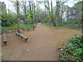
9
Part of Burgess Park
Like much of Burgess Park, this part of the park which leads from Waite Street through to Oakley Place past Cobourg Road Nature Reserve, is rather run down. The whole park is now being rejuvenated to the tune of £6 million, although this part does not seem to have been included in this programme.
Image: © Marathon
Taken: 16 Nov 2011
0.05 miles
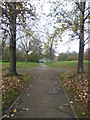
10
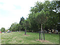
Planted pines in Burgess Park
These pine trees seemed an odd choice of planting for an English public park.
Image: © Stephen Craven
Taken: 17 Jul 2014
0.05 miles