IMAGES TAKEN NEAR TO
Colegrove Road, LONDON, SE15 6NG
Introduction
This page details the photographs taken nearby to Colegrove Road, SE15 6NG by members of the Geograph project.
The Geograph project started in 2005 with the aim of publishing, organising and preserving representative images for every square kilometre of Great Britain, Ireland and the Isle of Man.

There are currently over 7.5m images from over14,400 individuals and you can help contribute to the project by visiting https://www.geograph.org.uk
Image Map
Images are licensed for reuse under creativecommons.org/licenses/by-sa/2.0
Notes
- Clicking on the map will re-center to the selected point.
- The higher the marker number, the further away the image location is from the centre of the postcode.
Image Listing (79 Images Found)
Images are licensed for reuse under creativecommons.org/licenses/by-sa/2.0
Image
Details
Distance
1
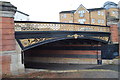
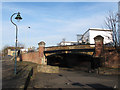
Canal bridge, Willowbrook Road
Bridge over the former Surrey Canal, at Willowbrook Road, looking north
Image: © Malc McDonald
Taken: 6 Mar 2010
0.01 miles
2

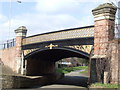
Abutment detail, Hill Street Bridge
The whole bridge is seen in Malc MacDonald's Image
Image: © Robin Stott
Taken: 26 Aug 2013
0.02 miles
4
Range of buildings by Willowbrook Road
A strange mixture of old and new, size and shape, seen from the Hill Street Bridge over the Surrey Canal Path. The whole bridge is seen in Malc MacDonald's Image
Image: © Robin Stott
Taken: 26 Aug 2013
0.02 miles
5

Spandrel and balustrade, Hill Street Bridge
The bridge took Willowbrook Road over the Surrey Canal, nowadays the Surrey Canal Path. It was being repainted. The whole bridge is seen in Malc MacDonald's Image
Image: © Robin Stott
Taken: 26 Aug 2013
0.02 miles
6

Plaque, Hill Street Bridge
It reads: S G C / Hill Street / Bridge / A D 1870
The bridge took Willowbrook Road over the Surrey Canal, nowadays the Surrey Canal Path. It was being repainted. The whole bridge is seen in Malc MacDonald's Image
Image: © Robin Stott
Taken: 26 Aug 2013
0.02 miles
7

A way in from Willowbrook Road to the Surrey Canal Path and Burgess Park
Image: © Robin Stott
Taken: 26 Aug 2013
0.02 miles
8
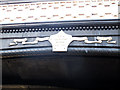
Willowbrook Road bridge - date plaque
The plaque is on the north spandrel of the bridge Image It reads: SCC [Surrey Canal Co.] Hill Street Bridge AD 1870. Presumably Hill Street was the old name for Willowbrook Road.
Image: © Stephen Craven
Taken: 10 Dec 2011
0.03 miles
9
Willowbrook Road bridge
The bridge originally carried the road over the Surrey Canal (Peckham branch). Now it allows pedestrians and cyclists to pass under the road in safety. See also Image
Image: © Stephen Craven
Taken: 10 Dec 2011
0.03 miles
10

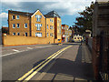
Villa, 48 Willowbrook Road
A house of Regency character that would have been close to the Surrey Canal at one time.
Image: © Robin Stott
Taken: 26 Aug 2013
0.03 miles