IMAGES TAKEN NEAR TO
Daniel Gardens, LONDON, SE15 6LP
Introduction
This page details the photographs taken nearby to Daniel Gardens, SE15 6LP by members of the Geograph project.
The Geograph project started in 2005 with the aim of publishing, organising and preserving representative images for every square kilometre of Great Britain, Ireland and the Isle of Man.

There are currently over 7.5m images from over14,400 individuals and you can help contribute to the project by visiting https://www.geograph.org.uk
Image Map
Images are licensed for reuse under creativecommons.org/licenses/by-sa/2.0
Notes
- Clicking on the map will re-center to the selected point.
- The higher the marker number, the further away the image location is from the centre of the postcode.
Image Listing (123 Images Found)
Images are licensed for reuse under creativecommons.org/licenses/by-sa/2.0
Image
Details
Distance
1
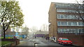
Daniel Gardens, SE15
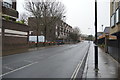
This image of Daniel Gardens, in North Peckham, was taken one morning in April 2014 when London's air quality was particularly poor. What looks like mist is in fact pollution.
Image: © Malc McDonald
Taken: 1 Apr 2014
0.04 miles
2
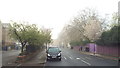
Sumner Road, SE15
Sumner Road in North Peckham. This image was taken one morning in April 2014 when London's air quality was particularly poor. What looks like mist or fog was in fact pollution.
Image: © Malc McDonald
Taken: 1 Apr 2014
0.05 miles
3
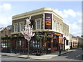
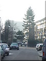
Ye Olde Apple Tree, Sumner Road, Camberwell.
Image: © Noel Foster
Taken: 10 Oct 2005
0.06 miles
4
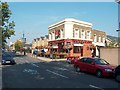
The Olde Apple Tree, Peckham
The Olde Apple Tree pub is on the corner of Sumner Road and Nutt Street in North Peckham.
This area was extensively redeveloped in the early 1970s, with traditional housing demolished and replaced by new council houses. However the pub survived.
Further redevelopment of the area was undertaken in the early 21st Century, with new buildings replacing some of the 1970s council housing.
Image: © Malc McDonald
Taken: 3 Apr 2011
0.08 miles
5
Waterside care home
An Anchor Housing Association home at 40 Sumner Road, Peckham. Waterside is "a nursing home that provides residential care, together with welcoming people with dementia and physical disabilities" according to its website http://www.anchor.org.uk/our-services/service-search/Waterside/ServiceDetail/serviceid=957 .
Image: © Stephen Craven
Taken: 4 Jun 2010
0.08 miles
6
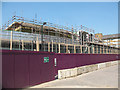
New buildings for Tuke School
Until 2010, Tuke Special School was situated on Woods Road Image
As of 2010 this replacement building was in construction, due to open in September 2010. It will "provide specialist facilities for all students with Profound and Complex Learning difficulties" according to the school's website http://www.tukeschool.co.uk/ .
Image: © Stephen Craven
Taken: 4 Jun 2010
0.08 miles
7
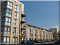
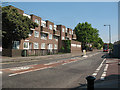
Gately Court
A newly completed apartment (c.2009/10) on Samuel Street, Peckham.
Image: © Stephen Craven
Taken: 4 Jun 2010
0.09 miles
8
January sunlight in Peckham
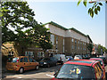
January sunlight on Samuel Street in Peckham. This densely-populated part of Inner London is within the North Peckham estate, which comprises mainly council housing. Some parts of the estate have undergone regeneration, with privately-owned houses and flats being built where council housing previously stood.
Image: © Malc McDonald
Taken: 19 Jan 2011
0.09 miles
10
Willowbrook Road, Peckham
Willowbrook Road is the continuation southwards of Trafalgar Avenue. For a view looking the otherway from the same spot, see Image The double-decker bus is on route 63 towards Kings Cross. Note the markings on the road for London Cycle Network route 22 that turns right here into Sumner road.
Image: © Stephen Craven
Taken: 4 Jun 2010
0.09 miles