IMAGES TAKEN NEAR TO
Sumner Road, LONDON, SE15 6JW
Introduction
This page details the photographs taken nearby to Sumner Road, SE15 6JW by members of the Geograph project.
The Geograph project started in 2005 with the aim of publishing, organising and preserving representative images for every square kilometre of Great Britain, Ireland and the Isle of Man.

There are currently over 7.5m images from over14,400 individuals and you can help contribute to the project by visiting https://www.geograph.org.uk
Image Map
Images are licensed for reuse under creativecommons.org/licenses/by-sa/2.0
Notes
- Clicking on the map will re-center to the selected point.
- The higher the marker number, the further away the image location is from the centre of the postcode.
Image Listing (105 Images Found)
Images are licensed for reuse under creativecommons.org/licenses/by-sa/2.0
Image
Details
Distance
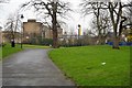
3
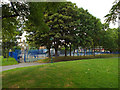
Playground, open space by Commercial Way
Image: © Robin Stott
Taken: 26 Aug 2013
0.02 miles
9
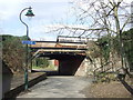
Commercial Way canal bridge
The bridge over the former Surrey Canal, at Commercial Way
Image: © Malc McDonald
Taken: 6 Mar 2010
0.07 miles
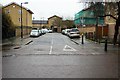
10
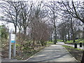
Surrey Canal path
The route of the former Surrey Canal, now a shared path for walking and cycling, looking southwards towards Peckham from near Commercial Way
Image: © Malc McDonald
Taken: 6 Mar 2010
0.08 miles