IMAGES TAKEN NEAR TO
Tower Mill Road, LONDON, SE15 6GP
Introduction
This page details the photographs taken nearby to Tower Mill Road, SE15 6GP by members of the Geograph project.
The Geograph project started in 2005 with the aim of publishing, organising and preserving representative images for every square kilometre of Great Britain, Ireland and the Isle of Man.

There are currently over 7.5m images from over14,400 individuals and you can help contribute to the project by visiting https://www.geograph.org.uk
Image Map
Images are licensed for reuse under creativecommons.org/licenses/by-sa/2.0
Notes
- Clicking on the map will re-center to the selected point.
- The higher the marker number, the further away the image location is from the centre of the postcode.
Image Listing (188 Images Found)
Images are licensed for reuse under creativecommons.org/licenses/by-sa/2.0
Image
Details
Distance
1
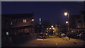
Pearse Street, North Peckham, after dark
Pearse Street in North Peckham, on a February evening after darkness has fallen. This street was created during regeneration of North Peckham during the early years of the 21st Century.
The lights in the distance are The Shard, which was western Europe's tallest building at the time this image was taken, and several other towers in the City of London. In front of The Shard is a high-rise block of flats, part of the Aylesbury Estate. The Aylesbury Estate is due to be redeveloped.
Image: © Malc McDonald
Taken: 9 Feb 2014
0.02 miles
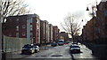
2
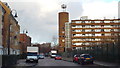
Christmas Day on Chandler Way, North Peckham
A view taken just after midday on Christmas Day 2013 along Chandler Way.
The housing to the left of the road dates from the early 21st Century, when the area was extensively regenerated. The block to the right of the image is older, it is part of Gloucester Grove Estate built in the early 1970s. Straight ahead in the distance is another housing block, part of the Aylesbury Estate which was developed in the 1960s and 1970s.
Image: © Malc McDonald
Taken: 25 Dec 2013
0.04 miles
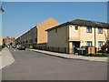
3
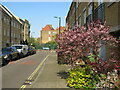
Lynbrook Grove, Peckham
Lynbrook Grove is a residential street in North Peckham. This street was built at the beginning of the 21st Century, as part of the regeneration of North Peckham. The school at the end of the street dates from Victorian times.
This image was taken in April, while spring blossom was out.
Image: © Malc McDonald
Taken: 17 Apr 2023
0.04 miles
4
Dragon Road, North Peckham
Autumn tree colour in Dragon Road, a residential road in North Peckham.
Image: © Malc McDonald
Taken: 26 Oct 2020
0.04 miles
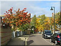
5
Lynbrook Grove, Peckham
Modern town houses built in around 2004 on Lynbrook Grove. The larger, older building at the far end of the street is a school Image
Image: © Stephen Craven
Taken: 4 Jun 2010
0.05 miles
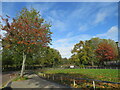
6
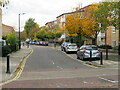
Christmas Day on Chandler Way, North Peckham,
A view looking southwards along Chandler Way in North Peckham, taken just after midday on Christmas Day 2013. This area was extensively regenerated at the beginning of the 21st Century.
Image: © Malc McDonald
Taken: 25 Dec 2013
0.05 miles
7
Watling Street, North Peckham
Autumn colour on Watling Street, a residential street in North Peckham.
Image: © Malc McDonald
Taken: 26 Oct 2020
0.06 miles
8
Autumn colours on Chandler Way, North Peckham
Autumn tree colours on Chandler Way in North Peckham.
Image: © Malc McDonald
Taken: 26 Oct 2020
0.06 miles
9
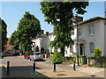
Older houses on Newent Close
Most of the housing in this area dates from the 1950s or later, i.e. post-war reconstruction, but these few houses on Newent Close look like a survival from an earlier era.
Image: © Stephen Craven
Taken: 4 Jun 2010
0.07 miles
10
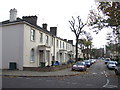
Newent Close, SE15
Traditional housing on Newent Close, in inner South East London. Much of the housing in this area was demolished in the 1960s and 1970s to make way for a large council housing estate. This terrace is one which survived.
In the immediate surrounds, the 1970s council housing has been demolished, replaced with new housing early in the 21st Century.
Image: © Malc McDonald
Taken: 26 Nov 2011
0.07 miles