IMAGES TAKEN NEAR TO
Pennack Road, LONDON, SE15 6DF
Introduction
This page details the photographs taken nearby to Pennack Road, SE15 6DF by members of the Geograph project.
The Geograph project started in 2005 with the aim of publishing, organising and preserving representative images for every square kilometre of Great Britain, Ireland and the Isle of Man.

There are currently over 7.5m images from over14,400 individuals and you can help contribute to the project by visiting https://www.geograph.org.uk
Image Map
Images are licensed for reuse under creativecommons.org/licenses/by-sa/2.0
Notes
- Clicking on the map will re-center to the selected point.
- The higher the marker number, the further away the image location is from the centre of the postcode.
Image Listing (100 Images Found)
Images are licensed for reuse under creativecommons.org/licenses/by-sa/2.0
Image
Details
Distance
3
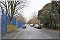
Willowbrook Road, Peckham
Willowbrook Road is the continuation southwards of Trafalgar Avenue. For a view looking the otherway from the same spot, see Image The double-decker bus is on route 63 towards Kings Cross. Note the markings on the road for London Cycle Network route 22 that turns right here into Sumner road.
Image: © Stephen Craven
Taken: 4 Jun 2010
0.03 miles
5
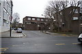
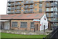
Waterside care home
An Anchor Housing Association home at 40 Sumner Road, Peckham. Waterside is "a nursing home that provides residential care, together with welcoming people with dementia and physical disabilities" according to its website http://www.anchor.org.uk/our-services/service-search/Waterside/ServiceDetail/serviceid=957 .
Image: © Stephen Craven
Taken: 4 Jun 2010
0.04 miles
7
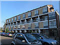
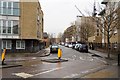
Site of the former All Saints church, North Peckham
This four-storey block of flats on the south side of Davey Street now stands on the site of the former church, which occupied the site from c.1892 to c.1952. It was not destroyed but taken down and rebuilt to a different design as Biggin Hill, St Mark (Rochester Diocese) Image in 1959. The parish was united in 1956 with that of St Andrew. This All Saints is not to be confused with the present church of the same name on Blenheim Grove Image
Image: © Stephen Craven
Taken: 14 Apr 2015
0.04 miles
8
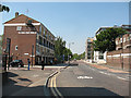
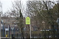
Trafalgar Avenue, Peckham
Looking north from the junction with Sumner Road. The cycle symbol on the road marks it as part of the London Cycle Network.
Image: © Stephen Craven
Taken: 4 Jun 2010
0.04 miles
9
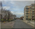
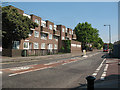
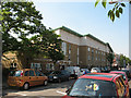
Sumner Road, Peckham
This road runs from Peckham centre to Old Kent Road. At the Peckham end, it is Peckham Hill St, at the Old Kent Road end Trafalgar Avenue and there is this section in the middle where it is Sumner Road.
Image: © Robert Eva
Taken: 1 Jan 2018
0.05 miles