IMAGES TAKEN NEAR TO
Pennack Road, LONDON, SE15 6DE
Introduction
This page details the photographs taken nearby to Pennack Road, SE15 6DE by members of the Geograph project.
The Geograph project started in 2005 with the aim of publishing, organising and preserving representative images for every square kilometre of Great Britain, Ireland and the Isle of Man.

There are currently over 7.5m images from over14,400 individuals and you can help contribute to the project by visiting https://www.geograph.org.uk
Image Map
Images are licensed for reuse under creativecommons.org/licenses/by-sa/2.0
Notes
- Clicking on the map will re-center to the selected point.
- The higher the marker number, the further away the image location is from the centre of the postcode.
Image Listing (78 Images Found)
Images are licensed for reuse under creativecommons.org/licenses/by-sa/2.0
Image
Details
Distance
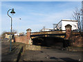
1
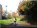
Peckham canal path
The cycleway follows the route of the Peckham branch of the Surrey Canal. The shadow of a bridge Image can be seen in the foreground.
Image: © Stephen Craven
Taken: 10 Dec 2011
0.02 miles
3

Surrey Canal Path, east end of Burgess Park, seen from Hill Street Bridge
The whole bridge is seen in Malc MacDonald's Image
Image: © Robin Stott
Taken: 26 Aug 2013
0.02 miles
4
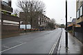
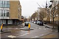
Willowbrook Road, Peckham
Willowbrook Road is the continuation southwards of Trafalgar Avenue. For a view looking the otherway from the same spot, see Image The double-decker bus is on route 63 towards Kings Cross. Note the markings on the road for London Cycle Network route 22 that turns right here into Sumner road.
Image: © Stephen Craven
Taken: 4 Jun 2010
0.04 miles
5
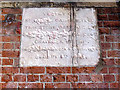
Defaced stone under Willowbrook Road bridge
The stone plaque has been sheltered by the bridge from natural erosion, but appears to have been deliberately defaced to erase names. It reads:
Vestry of St [G....] Camberwell. This stone was laid by [x] Esquire Chairman of the [z] Committee August 4th [yyyy]
The parish name [G.....] could be either Giles - the historic parish church - or George [St George's was nearer].
Image: © Stephen Craven
Taken: 10 Dec 2011
0.05 miles
7
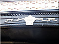
Willowbrook Road bridge - date plaque
The plaque is on the north spandrel of the bridge Image It reads: SCC [Surrey Canal Co.] Hill Street Bridge AD 1870. Presumably Hill Street was the old name for Willowbrook Road.
Image: © Stephen Craven
Taken: 10 Dec 2011
0.05 miles
9
Willowbrook Road bridge
The bridge originally carried the road over the Surrey Canal (Peckham branch). Now it allows pedestrians and cyclists to pass under the road in safety. See also Image
Image: © Stephen Craven
Taken: 10 Dec 2011
0.06 miles
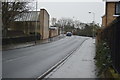
10
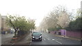
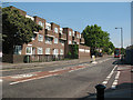
Sumner Road, SE15
Sumner Road in North Peckham. This image was taken one morning in April 2014 when London's air quality was particularly poor. What looks like mist or fog was in fact pollution.
Image: © Malc McDonald
Taken: 1 Apr 2014
0.06 miles