IMAGES TAKEN NEAR TO
Nigel Road, LONDON, SE15 4NP
Introduction
This page details the photographs taken nearby to Nigel Road, SE15 4NP by members of the Geograph project.
The Geograph project started in 2005 with the aim of publishing, organising and preserving representative images for every square kilometre of Great Britain, Ireland and the Isle of Man.

There are currently over 7.5m images from over14,400 individuals and you can help contribute to the project by visiting https://www.geograph.org.uk
Image Map
Images are licensed for reuse under creativecommons.org/licenses/by-sa/2.0
Notes
- Clicking on the map will re-center to the selected point.
- The higher the marker number, the further away the image location is from the centre of the postcode.
Image Listing (76 Images Found)
Images are licensed for reuse under creativecommons.org/licenses/by-sa/2.0
Image
Details
Distance
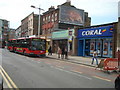
1
K2 Telephone Box, Peckham Rye
A Grade II listed phone box, on Nigel Road, outside the Image (in the background).
See http://www.britishlistedbuildings.co.uk/en-471143-k2-telephone-kiosk-outside-white-horse-p for more details.
Image: © David Anstiss
Taken: 25 Sep 2011
0.04 miles
2
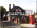
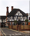
White Horse, Public House, Peckham Rye
On Nigel Road.
Image: © David Anstiss
Taken: 25 Sep 2011
0.04 miles
3
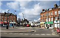
Peckham Rye
The shops on the right of Image can be seen on the left of this one. Directly ahead, set back at the start of Nigel Road, is the White Horse pub. To the right, the road narrows as shown in Image
Image: © Derek Harper
Taken: 11 Mar 2011
0.07 miles
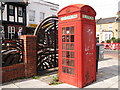
5
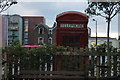
Phone box at White Horse, Peckham
Telephone boxes are becoming increasingly rare. This rather battered example still peers over the fence at drinkers in the White Horse garden at the South end of Rye Lane.
Image: © Robert Eva
Taken: 23 May 2016
0.08 miles
6
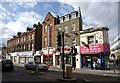
Rye Lane, Peckham Rye
To the left, Rye Lane (the A2215) opens out at the northern tip of the common.
Image: © Derek Harper
Taken: 11 Mar 2011
0.08 miles
7
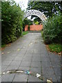
McDermott Road Community Garden
McDermott Road Community Garden has entrances on McDermott Road and Costa Street. This is the approach from Costa Street. The garden used to be on the west side of Costa Street in the playground of Bellenden Primary School but was relocated over the road. It was featured in Charlie Dimmock's TV show 'Charlie's Garden Army'.
Image: © Marathon
Taken: 31 Aug 2011
0.08 miles
8
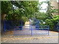
Entrance to McDermott Road Community Garden
Seen across Costa Street, McDermott Road Community Garden also has an entrance on McDermott Road. The garden used to be on the west side of Costa Street in the playground of Bellenden Primary School but was relocated over the road. It was featured in Charlie Dimmock's TV show 'Charlie's Garden Army'.
Image: © Marathon
Taken: 31 Aug 2011
0.08 miles
9
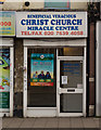
Storefront church, Peckham
One of a number of Black Majority Churches in the United Kingdom.
Image: © Jim Osley
Taken: 13 Jan 2016
0.09 miles